 Filter: Categories of Wisconsin Historical Images
Filter: Creator Name of Vinje, Arthur M., 1888-1972
Filter: Year of 1900-1999
Filter: Year of 1920-1929
Filter: Categories of Wisconsin Historical Images
Filter: Creator Name of Vinje, Arthur M., 1888-1972
Filter: Year of 1900-1999
Filter: Year of 1920-1929
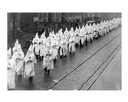
| Date: | 12 05 1924 |
|---|---|
| Description: | Ku Klux Klan (KKK) wearing iconic masks and white robes parading down King Street to Schroeder Funeral Home for the funeral of Police officer Herbert Drege... |
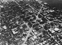
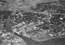
| Date: | 1928 |
|---|---|
| Description: | Aerial view of Capitol Square and vicinity, looking east-northeast. State Street is visible at the bottom center. |
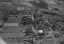
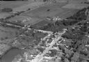
| Date: | 10 1928 |
|---|---|
| Description: | Aerial view of DeForest including residences and the surrounding countryside. |

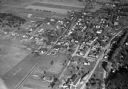
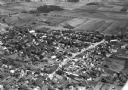
| Date: | 11 1928 |
|---|---|
| Description: | Aerial view of Verona including businesses, houses, and the surrounding farm land. |
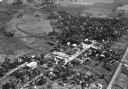
| Date: | 11 1928 |
|---|---|
| Description: | Aerial view of Middleton including businesses, residences, the railroad tracks, and the surrounding countryside. |
| Date: | 11 1928 |
|---|---|
| Description: | Aerial view of Stoughton including the central business district, the Yahara River, and the surrounding countryside. |
| Date: | 10 1928 |
|---|---|
| Description: | Aerial view of Belleville, including the central business disctrict and the surrounding countryside. |

| Date: | 10 1928 |
|---|---|
| Description: | Aerial view of Sun Prairie, including the central business district, residences, and the surrounding countryside stretching to the horizon. |
| Date: | 10 1928 |
|---|---|
| Description: | Aerial view of Sun Prairie, including the central business district, residences, and the surrounding countryside. |

| Date: | 10 1928 |
|---|---|
| Description: | Aerial view of Mount Horeb, including the central business district. |

| Date: | 11 1928 |
|---|---|
| Description: | Aerial view of Stoughton, including the central business district, residential areas, the Yahara River, and the surrounding countryside. |

| Date: | 11 1928 |
|---|---|
| Description: | Aerial view residential areas of Windsor and the surrounding countryside. |

| Date: | 11 1928 |
|---|---|
| Description: | Aerial view of Black Earth residential area and the surrounding countryside. |
| Date: | 11 1928 |
|---|---|
| Description: | Aerial view of Oregon, including the central business disctrict, residential areas, schools, and the surrounding countryside. |

| Date: | 11 1928 |
|---|---|
| Description: | Aerial view of Cross Plains, including residences and the surrounding countryside. |

| Date: | 06 22 1925 |
|---|---|
| Description: | Robert, Jr., Belle Case, and Philip La Follette in foreground; Mr. and Mrs. Ralph Sucher follow, and George Middleton in background. To the left: E.N. Warn... |
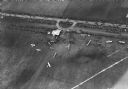
| Date: | 10 06 1928 |
|---|---|
| Description: | Aerial view of the Janesville airport during air races including airplanes in the air, the landing field, and airport structures. |

| Date: | 1929 |
|---|---|
| Description: | Aerial view of a construction site surrounded by woods. Lake View Tuberculosis Sanatorium(?). |
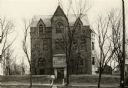
| Date: | 1920 |
|---|---|
| Description: | The building at 309 West Washington Avenue was built in 1891 for the St. Regina Convent and Academy of the Sinsinawa Dominican nuns across the street from ... |
If you didn't find the material you searched for, our Library Reference Staff can help.
Call our reference desk at 608-264-6535 or email us at:
