 Filter: Categories of Wisconsin Historical Images
Filter: Creator Name of Vinje, Arthur M., 1888-1972
Filter: Subject of wisconsin river (wis.)
Filter: Categories of Wisconsin Historical Images
Filter: Creator Name of Vinje, Arthur M., 1888-1972
Filter: Subject of wisconsin river (wis.)
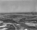
| Date: | |
|---|---|
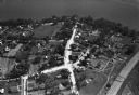
| Description: | Aerial view of the town, including the Wisconsin River, and the surrounding countryside. |
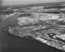
| Date: | 1930 |
|---|---|
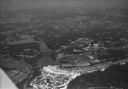
| Description: | Aerial view of the town of Wisconsin Dells, the dam on the Wisconsin River, and the generating plant. The town of Wisconsin Dells was known as Kilbourn Cit... |

| Date: | 1930 |
|---|---|
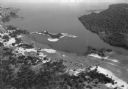
| Description: | Aerial view of Wisconsin Dells including the Wisconsin River and the dam and generating power plant. |
| Date: | 1930 |
|---|---|
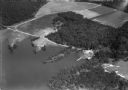
| Description: | Aerial view of Lake Delton, the Wisconsin River, and the surrounding countryside. |
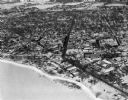
| Date: | 1930 |
|---|---|
| Description: | Aerial view of Lake Delton and shoreline including resort areas. |
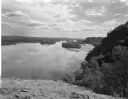
| Date: | 08 03 1946 |
|---|---|
| Description: | View of the Wisconsin River from Cactus Bluff. |
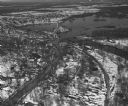
| Date: | 02 09 1949 |
|---|---|
| Description: | One of five aerial views of Portage, including the frozen Wisconsin River. |
| Date: | 04 16 1949 |
|---|---|
| Description: | Aerial view of Necedah, Wisconsin, and Petenwell Lake behind Petenwell Dam on the Wisconsin River. |
| Date: | 04 16 1949 |
|---|---|
| Description: | Aerial view of Castle Rock Dam on the Wisconsin River near Mauston, Wisconsin. |
| Date: | 04 16 1949 |
|---|---|
| Description: | Aerial view of Petenwell Dam and dike on Wisconsin River twenty miles north of Necedah, Wisconsin showing the early formation of Lake Petenwell. |
If you didn't find the material you searched for, our Library Reference Staff can help.
Call our reference desk at 608-264-6535 or email us at: