 Filter: Categories of Wisconsin Historical Images
Filter: Creator Name of Unknown
Filter: Year of 1800-1899
Filter: Year of 1830-1839
Filter: Categories of Wisconsin Historical Images
Filter: Creator Name of Unknown
Filter: Year of 1800-1899
Filter: Year of 1830-1839
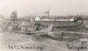
| Date: | 1834 |
|---|---|
| Description: | Reproduction of an oil painting of Fort Winnebago, which was built in 1827 by Major William Whistler and a detachment of the First Infantry. Caption reads:... |
| Date: | 1833 |
|---|---|
| Description: | Illustration of the Solomon Juneau fur trading post at Milwaukee in 1833. |

| Date: | 07 1838 |
|---|---|
| Description: | A map diagram of Indian effigy mounds seven miles east of Blue Mounds in the Wisconsin Territory. |
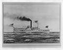
| Date: | 1832 |
|---|---|
| Description: | An early type of sidewheel passenger and freight steamboat The Milwaukie, also known as The Milwaukee. It was used on Lake Erie and upper lak... |

| Date: | 1831 |
|---|---|
| Description: | Drawing of Fort Winnebago (near present-day Portage) that illustrated "Wau-Bun," Juliette Kinzie's memoir of her experiences on the early Wisconsin fronti... |

| Date: | 1836 |
|---|---|
| Description: | Map of all Dane County and eastern towns. |

| Date: | 1839 |
|---|---|
| Description: | A map of the Wiskonsin [sic] and Neenah or Fox Rivers. |
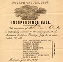
| Date: | 06 27 1839 |
|---|---|
| Description: | Invitation for Darwin Clark to the Independence Ball on the 4th of July, 1839 at the American Hotel. |

| Date: | 1836 |
|---|---|
| Description: | The top map is the "Plat of Madison the Capitol of Wisconsin." The bottom map is the "Map of the Four Lake Country. Taken from the Township Maps in the U.S... |
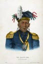
| Date: | 1838 |
|---|---|
| Description: | Wau-Baun-See, a hand-colored lithographic portrait of a Potawatamie Indian. This image from McKenney & Hall's "History of the Indian Tribes," (1849-1850) ... |

| Date: | 1830 |
|---|---|
| Description: | Illustration of Fort Crawford. Caption reads: "Fort Crawford in 1830, Prairie Du Chien, Wis." |

| Date: | 03 30 1835 |
|---|---|
| Description: | Map of township # 7N, range no. 10 east, 4th meridian, including Third Lake. |
| Date: | 1835 |
|---|---|
| Description: | Engraving entitled "Tomb of Washington--Mount Vernon". |
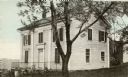
| Date: | 1832 |
|---|---|
| Description: | People work in the garden at the Protestant Episcopal Mission Buildings. |

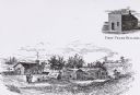
| Date: | 1832 |
|---|---|
| Description: | Route of Military Road from Fort Crawford to Fort Howard. Map shows beginning of route at Fort Crawford. |

| Date: | 1836 |
|---|---|
| Description: | The map of Wisconsin City on the Wisconsin River. |
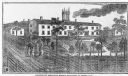
| Date: | 1838 |
|---|---|
| Description: | The Odd Fellows Hall, built in 1837-1838, was the first to be built west of the Allegheny Mountains. The cornerstones were laid by Thomas Widley. |
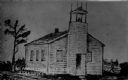
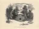
| Date: | 1835 |
|---|---|
| Description: | Drawing of the Stockbridge Indian mission. |

| Date: | 07 01 1836 |
|---|---|
| Description: | Original plat map of the town of Madison on the four lakes. |

| Date: | 1838 |
|---|---|
| Description: | Compiled from the latest authorities. Published by Hinman and Dutton. |
If you didn't find the material you searched for, our Library Reference Staff can help.
Call our reference desk at 608-264-6535 or email us at: