 Filter: Categories of Wisconsin Historical Images
Filter: Creator Name of Unknown
Filter: County of Brown
Filter: Categories of Wisconsin Historical Images
Filter: Creator Name of Unknown
Filter: County of Brown

| Date: | |
|---|---|
| Description: | This 19th century manuscript map shows lots and acreages in northern Green Bay, Wisconsin, east of the Fox River. "Preble Township, Brown County, Wis." is ... |
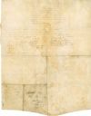
| Date: | 08 18 1821 |
|---|---|
| Description: | The reverse side of the Green Bay treaty, August 18, 1821. The treaty is signed by the chiefs of the six Indian nations for the possession of lands near th... |

| Date: | 1830 |
|---|---|
| Description: | Plat map showing lots and streets. A few lots are marked with names, including: Boyd, Newton, Williams, Baird, Suydam, etc. |
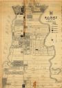
| Date: | 1947 |
|---|---|
| Description: | Map shows land ownership, residential zones, commercial zones, and light industrial zones. Includes inset and location map. Also includes zoning ordinance ... |
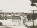
| Date: | 1908 |
|---|---|
| Description: | Looking down hill southeast across the Fox River bridge. Industrial buildings line the shoreline on the far side. |

| Date: | 09 20 1836 |
|---|---|
| Description: | This map is ink and watercolor on paper and is an unnamed plat. Green Bay is labeled and the plat is labeled "Section 22." One road is labeled "Road to Nav... |

| Date: | 1900 |
|---|---|
| Description: | This map of West Navarino shows plat of the town, lots by number, local streets, public square, The Fox River, and Fort Howard. The bottom of the map reads... |

| Date: | 1800 |
|---|---|
| Description: | This map of the Little Kaukalin Region is ink on paper and shows Little Kaukalin Rapids, Black Bird Island, buildings, trails, meadows and woods, and a sug... |

| Date: | 1930 |
|---|---|
| Description: | This map shows a plat of the town, local streets, railroads, creeks, part of Fox River, and part of the bay of Green Bay. The location of the original fort... |
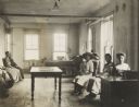
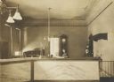
| Date: | 1912 |
|---|---|
| Description: | Interior of an office of the Wisconsin State Employment Service, with applicants for work, and officials. |
| Date: | 1910 |
|---|---|
| Description: | Elmer S. Hall and his daughter, Olive Hall, in the County Clerk's office. |

| Date: | 1914 |
|---|---|
| Description: | This map has relief shown by hachures and shows local streets, wards, districts, railroads, Fox River, and part of Bay of Green Bay. Wards are shown in dar... |
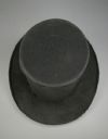
| Date: | |
|---|---|
| Description: | Overhead view of a top hat made from beaver felt, worn by Green Bay resident Morgan L. Martin. |
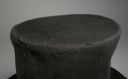
| Date: | |
|---|---|
| Description: | The frayed edge of a top hat made from beaver felt, worn by Green Bay resident Morgan L. Martin. |
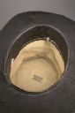
| Date: | |
|---|---|
| Description: | View of the inside of a top hat made from beaver felt, worn by Green Bay resident Morgan L. Martin. The maker's label reads: "Orel Cook, Rutland, Vt." |
| Date: | |
|---|---|
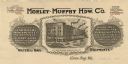
| Description: | Letterhead of the Morley-Murphy Hardware Company, with a three-quarter view of the company building and horse, streetcar, and rail traffic around it. |

| Date: | 1905 |
|---|---|
| Description: | Elevated view of a wagon crossing the bridge over the Fox River at De Pere. Caption reads: "Greetings from De Pere, Wis." and "Bridge, Fox River." |

| Date: | 1920 |
|---|---|
| Description: | Color-enhanced postcard with an elevated view of the dam and swing bridge over the lock on the Fox River. Caption reads: "Birdseye View of Dam and Bridge o... |

| Date: | 1875 |
|---|---|
| Description: | Handwritten note on back identifies this elevated view as the west side of Broadway from National Bank, looking south. The Fox River is in the background o... |

| Date: | 1910 |
|---|---|
| Description: | Photographic postcard of elevated view of the Wilcox Stone Mill, and part of Broadway showing the rear view of B.F. Smith's store below the hand-drawn arro... |
If you didn't find the material you searched for, our Library Reference Staff can help.
Call our reference desk at 608-264-6535 or email us at: