 Filter: Categories of Wisconsin Historical Images
Filter: Creator Name of Unknown
Filter: County of Brown
Filter: Subject of human settlements
Filter: Categories of Wisconsin Historical Images
Filter: Creator Name of Unknown
Filter: County of Brown
Filter: Subject of human settlements

| Date: | |
|---|---|
| Description: | An football shaped sticker with the words "Green Bay Packers" over a map of Wisconsin, with Green Bay and Milwaukee identified. There is also an image of a... |
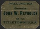
| Date: | 01 1963 |
|---|---|
| Description: | A shiny sticker for the inauguration of Wisconsin Governor John W. Reynolds (4/4/1921 – 1/6/2002), Jr. that highlights his status as a native of "Titletown... |
| Date: | |
|---|---|
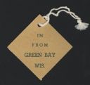
| Description: | A one-sided badge with the words "I'm From Green Bay Wis." printed on it. |
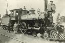
| Date: | 1896 |
|---|---|
| Description: | Railroad employees pose with locomotive engine no. 925 of the Chicago, Milwaukee & St. Paul Railway. The engine has a long pilot, a large oil headlight, sm... |
| Date: | |
|---|---|
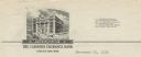
| Description: | Letterhead of the Farmers Exchange Bank of Green Bay, Wisconsin, with a three-quarter view of the bank building and people walking on the sidewalk. There a... |

| Date: | |
|---|---|
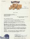
| Description: | Memohead of the Henry Rahr Sons' Company of Green Bay, Wisconsin, brewers and maltsters, with an elevated view of the main office at 1317-1323 Main St. on ... |
| Date: | |
|---|---|
| Description: | Letterhead of Steve's Cheese of Denmark, Wisconsin, with a man standing amidst seven large (300-12,000 lbs.) wheels of cheese on individual pallets, and a ... |

| Date: | 1914 |
|---|---|
| Description: | This map is a photostat copy from the original 1829 map in the War Department. The map shows location of Fort Howard, lots, land claims of Jacques Porlier ... |
| Date: | 1930 |
|---|---|
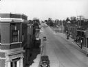
| Description: | Elevated view of High Street (Highway 96) and the bridge over the Fox River at Wrightstown. Farmers & Traders Bank is at left, a sign for Meuleman's Elect... |

| Date: | 1908 |
|---|---|
| Description: | This 1908 map shows the township and range grid, sections, towns, villages, railroads, bridges, lakes, streams, rapids, and state-owned lands in Oneida Cou... |

| Date: | 1959 |
|---|---|
| Description: | This map identifies public forest land and industrial forest land as of 1959 in Oneida County, Wisconsin, using a 1930 base map showing the township and ra... |

| Date: | |
|---|---|
| Description: | This 19th century manuscript map shows lots and acreages in northern Green Bay, Wisconsin, east of the Fox River. "Preble Township, Brown County, Wis." is ... |

| Date: | 1830 |
|---|---|
| Description: | Plat map showing lots and streets. A few lots are marked with names, including: Boyd, Newton, Williams, Baird, Suydam, etc. |
| Date: | 1947 |
|---|---|
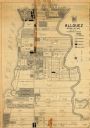
| Description: | Map shows land ownership, residential zones, commercial zones, and light industrial zones. Includes inset and location map. Also includes zoning ordinance ... |
| Date: | 1908 |
|---|---|
| Description: | Looking down hill southeast across the Fox River bridge. Industrial buildings line the shoreline on the far side. |

| Date: | 09 20 1836 |
|---|---|
| Description: | This map is ink and watercolor on paper and is an unnamed plat. Green Bay is labeled and the plat is labeled "Section 22." One road is labeled "Road to Nav... |

| Date: | 1900 |
|---|---|
| Description: | This map of West Navarino shows plat of the town, lots by number, local streets, public square, The Fox River, and Fort Howard. The bottom of the map reads... |

| Date: | 1930 |
|---|---|
| Description: | This map shows a plat of the town, local streets, railroads, creeks, part of Fox River, and part of the bay of Green Bay. The location of the original fort... |

| Date: | 1914 |
|---|---|
| Description: | This map has relief shown by hachures and shows local streets, wards, districts, railroads, Fox River, and part of Bay of Green Bay. Wards are shown in dar... |

| Date: | 1905 |
|---|---|
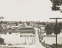
| Description: | Elevated view of a wagon crossing the bridge over the Fox River at De Pere. Caption reads: "Greetings from De Pere, Wis." and "Bridge, Fox River." |
If you didn't find the material you searched for, our Library Reference Staff can help.
Call our reference desk at 608-264-6535 or email us at: