 Filter: Categories of Wisconsin Historical Images
Filter: Creator Name of Unknown
Filter: County of Adams
Filter: Categories of Wisconsin Historical Images
Filter: Creator Name of Unknown
Filter: County of Adams
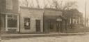
| Date: | 1910 |
|---|---|
| Description: | View of some storefronts, including a lunch room, and a library on a dirt road. |

| Date: | |
|---|---|
| Description: | View of a large geological rock formation at the base of a river or lake. |

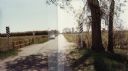
| Date: | 1986 |
|---|---|
| Description: | Panoramic view of the intersection of County Z and F, looking east from Z. The view shows several rural bars and restaurants. |
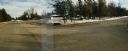
| Date: | 1987 |
|---|---|
| Description: | Panoramic view of the intersection of county highways Z (15th Avenue) and D in rural Adams County, looking east and south to a bar at the corner. |
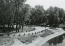
| Date: | 09 20 1972 |
|---|---|
| Description: | Wayside #8 near Necedah in rural Adams County. |
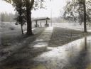
| Date: | 09 30 1970 |
|---|---|
| Description: | Point Bluff Wayside as viewed from the highway bridge above. |
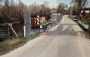
| Date: | 05 02 1985 |
|---|---|
| Description: | Bridge over Duck Creek in the Town of Adams, Adams County, Wisconsin. |
| Date: | 05 02 1985 |
|---|---|
| Description: | Bridge over White Creek in the Town of Easton, Adams County, Wisconsin. |
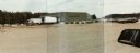
| Date: | 03 21 1986 |
|---|---|
| Description: | Office and metal warehouse of Potato World, Inc., located on County Highway E near Grand Marsh in Adams County. |
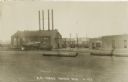
| Date: | |
|---|---|
| Description: | Photographic postcard of the railroad yard. Across an empty yard where a few large pipes lay, a locomotive with smoking stack and cars is on railroad track... |
| Date: | |
|---|---|
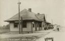
| Description: | Photographic postcard of the Chicago and North Western Depot. A group of children are in front of the depot near a cart, and two men work nearby. |
| Date: | |
|---|---|
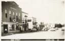
| Description: | Photographic postcard of Main Street. Businesses line the street, including the Adams Auto Company Dodge-Plymouth, McBride Equipment Company, and McCormick... |
| Date: | |
|---|---|
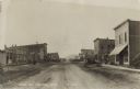
| Description: | Photographic postcard of Main Street. People, automobiles, and horse-drawn vehicles line the dirt-covered street and sidewalks. A Gold Medal Flour billboar... |

| Date: | |
|---|---|
| Description: | Photographic postcard of a geological rock formation. Side view of the snow-covered bluff and rocks surrounded by trees. Two children stand on a ledge next... |

| Date: | 01 01 1856 |
|---|---|
| Description: | This map is mounted on cloth and shows lots, as well as location of the public square and college. Streets are labeled as is the Wisconsin River. |
| Date: | |
|---|---|
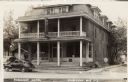
| Description: | View across street towards the Friendship Hotel, including a tavern and cafe. Automobiles are parked in front. There are Coca-Cola signs under the front wi... |

| Date: | 1908 |
|---|---|
| Description: | View of Main Street in Friendship. The J.Hill & Son General Store is on the right, with two women at the entrance. Horse-drawn vehicles are in the street. |

| Date: | |
|---|---|
| Description: | View of Friendship Mound — a rocky outcropping, from the road below. |

| Date: | |
|---|---|
| Description: | Hand-colored postcard of Rabbit Rock — a rocky outcropping with two towers of stone. |
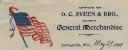
| Date: | 05 29 1899 |
|---|---|
| Description: | Letterhead for O.C. Sveen & Bro., featuring an image of the American flag on the left. Text reads: "Office of O.C. Sveen & Bro., Dealers in General Merchan... |
If you didn't find the material you searched for, our Library Reference Staff can help.
Call our reference desk at 608-264-6535 or email us at: