 Filter: Categories of Wisconsin Historical Images
Filter: Creator Name of Unknown
Filter: Community of Prairie du Chien
Filter: Categories of Wisconsin Historical Images
Filter: Creator Name of Unknown
Filter: Community of Prairie du Chien
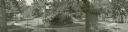
| Date: | |
|---|---|
| Description: | Composite panoramic view showing gazebo, star bed, and southeast corner of the lawn. |

| Date: | |
|---|---|
| Description: | Panoramic view of southwest corner of Villa Louis lawn. The house and a path can be seen at right. |

| Date: | |
|---|---|
| Description: | Panoramic view of the east lawn at Villa Louis. The house and office building can be seen at right. |
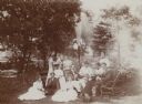
| Date: | 1898 |
|---|---|
| Description: | Group of twelve people, including Nina Dousman, gathered around a table outdoors, with a fountain spouting water in the background. Four people play cards ... |
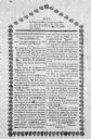
| Date: | 08 11 1851 |
|---|---|
| Description: | Photograph of the death notice of Daniel G. Fenton, a Judge of the County Court, published by the Members of the Bar of Crawford County. |

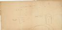
| Date: | 1830 |
|---|---|
| Description: | This early 19th century manuscript map of Prairie du Chien, Wisconsin, shows sections, landownership and acreages, roads, and ferries in the towns of Bridg... |

| Date: | |
|---|---|
| Description: | An outdoor family portrait with a golf theme. Several members are sitting on a bench and the lawn, with a large house in the background. There are two dogs... |

| Date: | |
|---|---|
| Description: | A man and two women pose in a four seat buggy. They are wearing suits, dresses and hats. Buildings and a fence appear in the background. |

| Date: | 1910 |
|---|---|
| Description: | Interior of Koska Hall on the third floor of Campion Jesuit High School. This was used as a study hall. |

| Date: | 1882 |
|---|---|
| Description: | This map is ink on cardboard and shows the location of military forts over the course of years. Also shown are points of interest, streets, the Mississippi... |

| Date: | 1864 |
|---|---|
| Description: | This map is ink, pencil, and color on paper and shows numbered lots and labeled streets. The bottom margin of the map reads: "Recorded in the Registry of d... |

| Date: | 1800 |
|---|---|
| Description: | This map is ink and watercolor on paper and shows the main channel and sand bars in the Mississippi River between villages. |

| Date: | 1830 |
|---|---|
| Description: | This map is ink, color, and pencil on paper and shows streets, farm lots, and a church. Handwritten notes are at the bottom of the map and are very light. |

| Date: | 1838 |
|---|---|
| Description: | This map is a development plat that shows street names, numbered blocks and lots, and small farm lot owners. Included on the right of the map is a large am... |

| Date: | 1828 |
|---|---|
| Description: | This plat map is pen-and-ink and shows landowners, the Mississippi River, the Marais de St. Friole, Fort Crawford, the town commons, and the Village of St.... |

| Date: | 09 01 1856 |
|---|---|
| Description: | This map is pen-and-ink and shows farm lots, other lots of land sectioned by acres, bluffs, and a coulee. Also included are notations in pencil and blue in... |

| Date: | 1858 |
|---|---|
| Description: | This map shows streets, lots, and landownership. Also included are notations in pencil and blue colored pencil. Some lots are colored in blue, green, or br... |
| Date: | |
|---|---|
| Description: | This map shows farm lots and private land claims on Prairie du Chien. The bottom left margin reads: "Part of sec. 1, T6 N, R 7W and sec. 36, T 7N, R 7W. S... |

| Date: | 1865 |
|---|---|
| Description: | This is a collection of two plat maps. The first map shows lots, streets, and farm lot 25. Written in ink, the top of the map reads: Plat of Prairie du Chi... |

| Date: | 1856 |
|---|---|
| Description: | This map shows lot and block numbers, streets, depot building, and the Milwaukee & Mississippi Rail Road. |
If you didn't find the material you searched for, our Library Reference Staff can help.
Call our reference desk at 608-264-6535 or email us at: