 Filter: Categories of Wisconsin Historical Images
Filter: Creator Name of Rand McNally
Filter: Categories of Wisconsin Historical Images
Filter: Creator Name of Rand McNally

| Date: | 1952 |
|---|---|
| Description: | This colored map shows the entire state, along with counties in states bordering Wisconsin. There is a key to "Wisconsin Railroads," with initials identify... |

| Date: | 1952 |
|---|---|
| Description: | This colored map shows the entire state, along with counties in states bordering Wisconsin. There is a key to "Wisconsin Railroads," with initials identify... |

| Date: | 1919 |
|---|---|
| Description: | This map contains the automobile routes in southern Wisconsin and northern Illinois. Cities, Lake Winnebago and Green Bay are labeled. The orange print on ... |

| Date: | 1924 |
|---|---|
| Description: | This map shows automobile routes across the state and into parts of Minnesota, Iowa, Illinois, and Michigan. Cities, Lake Michigan, Lake Superior, Green Ba... |

| Date: | 1920 |
|---|---|
| Description: | This map details automobile routes spanning across Wisconsin and parts of Illinois, Michigan, Minnesota, and Iowa. Cities, counties, Lake Michigan, Lake Su... |

| Date: | 1910 |
|---|---|
| Description: | This map shows automobile routes across the state as well as Minnesota, Iowa, Illinois, and Michigan. Cities, Lake Michigan, Lake Superior, the Mississippi... |

| Date: | 1927 |
|---|---|
| Description: | This map details automobile routes throughout the state as well as parts of Iowa, Minnesota, Michigan and Illinois. Cities, the Mississippi River, Lake Mic... |

| Date: | 1890 |
|---|---|
| Description: | This late 19th century map shows mining companies' lands and miscellaneous properties in the towns of Cady and Springfield in southeastern Saint Croix Coun... |

| Date: | 1900 |
|---|---|
| Description: | This map, which shows the state of Wisconsin in 1895, was published as Rand, McNally & Co.'s New business atlas map of Wisconsin. Railroads, counties, citi... |

| Date: | 1892 |
|---|---|
| Description: | Bird's-eye view of the Columbian Exposition pavilions from the vantage point of Lake Michigan. Included is an inset of the Union Passenger Station (now Uni... |

| Date: | 1883 |
|---|---|
| Description: | A hand-colored map of Wisconsin showing counties, cities, villages, railroads, lakes, and rivers in the state. The map also includes the eastern portions o... |

| Date: | 1896 |
|---|---|
| Description: | Map highlighting parks and other points of interest in Milwaukee. |

| Date: | 1910 |
|---|---|
| Description: | A business map of Wisconsin, showing railroads, counties, cities, villages, rivers, lakes, and electric lines. Additional areas also included in the map ar... |

| Date: | 1896 |
|---|---|
| Description: | A map of Green Lake County, Wisconsin, shows township divisions, villages and post offices, railroads, roads, lakes and streams, schools, and churches. |

| Date: | 1908 |
|---|---|
| Description: | A business map of Wisconsin, showing railroads, counties, cities, villages, rivers, and lakes. Additional areas shown in the map include the western portio... |
| Date: | 1874 |
|---|---|
| Description: | A folded brochure with a map of the Chicago to Saint Paul rail line through Wisconsin by way of the Chicago & North-Western and West Wisconsin Railways. Th... |

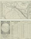
| Date: | 1940 |
|---|---|
| Description: | Shows Milwaukee and Waukesha counties, and parts of Dodge, Washington, Ozaukee, Jefferson, Walworth, and Racine counties. Includes indexes of "Cities, Town... |

| Date: | 1892 |
|---|---|
| Description: | A cloth mounted, hand-colored map of Wisconsin showing the rail routes, counties, cities, towns, rivers and lakes in the state. The map also shows eastern ... |

| Date: | 1910 |
|---|---|
| Description: | This map shows railroads, counties, cities and villages, rivers, lakes, and electric lines are shown in Wisconsin, the western portion of Michigan's Upper ... |
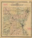
| Date: | |
|---|---|
| Description: | Map shows townships, roads and railroads, churches, schools, and selected buildings and property owners. |
If you didn't find the material you searched for, our Library Reference Staff can help.
Call our reference desk at 608-264-6535 or email us at: