Visit our other Wisconsin Historical Society websites!
 Filter: Categories of Wisconsin Historical Images
Filter: Creator Name of Newhouse, John
Filter: Categories of Wisconsin Historical Images
Filter: Creator Name of Newhouse, John

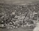
| Date: | 1955 |
|---|---|
| Description: | Aerial view of Mineral Point showing State Highway 23-39 under construction. |

| Date: | 1955 |
|---|---|
| Description: | An aerial view of Mineral Point showing the construction of State Highway 23-39. |
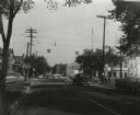
| Date: | 1955 |
|---|---|
| Description: | The intersection of Johnson and Broom Streets. |

| Date: | 1955 |
|---|---|
| Description: | Doctors Lindley and John T. Sprague house, 109 East Johnson Street. |

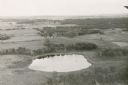
| Date: | |
|---|---|
| Description: | Aerial view of the Crestwood neighborhood. |
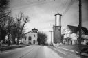
| Date: | 1940 |
|---|---|
| Description: | View down a street in Sun Prairie, including a home, watertower, and church. |

| Date: | 1940 |
|---|---|
| Description: | Exterior view of the school of the Sacred Heart of Jesus and Mary. |

| Date: | 1940 |
|---|---|
| Description: | Front exterior view of the Sun Prairie Public Library with a police car parked in front of it. |

| Date: | 1940 |
|---|---|
| Description: | Exterior view of a high school and the parking lot in front of it. |
| Date: | 1940 |
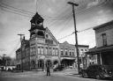
|---|---|
| Description: | View of the city hall and the various buildings surrounding it. |

| Date: | 1955 |
|---|---|
| Description: | A public bus crosses the bridge over a ravine on Lake Mendota Drive in Shorewood, looking east. |

| Date: | 1955 |
|---|---|
| Description: | Bridge over a ravine on Lake Mendota Drive in Shorewood Hills, looking west. |

| Date: | |
|---|---|
| Description: | Aerial view of a full Camp Randall Stadium during half-time of a football game. The band is on the field in formation to spell "UW." |

| Date: | 1940 |
|---|---|
| Description: | Exterior view of the Wisconsin Seed Company, Funk's Hybrid, with several automobiles parked beside it. |
| Date: | 1945 |
|---|---|
| Description: | View of the Midway Barns, constructed in 1938 on the farmland adjoining Taliesin, Frank Lloyd Wright's residence and architectural school complex. Taliesin... |

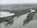
| Date: | 1945 |
|---|---|
| Description: | Aerial view of Taliesin, Frank Lloyd Wright's residence and architectural school complex, with the Wisconsin River visible at the top. Taliesin is located... |
If you didn't find the material you searched for, our Library Reference Staff can help.
Call our reference desk at 608-264-6535 or email us at: