 Filter: Categories of Wisconsin Historical Images
Filter: Creator Name of Newhouse, John
Filter: Subject of water
Filter: Categories of Wisconsin Historical Images
Filter: Creator Name of Newhouse, John
Filter: Subject of water

| Date: | 07 07 1954 |
|---|---|
| Description: | Aerial view of group of buildings on the north east campus of the University of Wisconsin, including the Historical Library, University Library, old Scienc... |

| Date: | |
|---|---|
| Description: | Aerial view over Monona Bay showing two railroads crossing in the center. Olin Park is on the top left. |

| Date: | 1968 |
|---|---|
| Description: | Aerial view looking southwest, with Lake Mendota at right and East Gorham Street running from the bottom left corner. Lincoln School is in the foreground, ... |

| Date: | 1960 |
|---|---|
| Description: | Air view of the Lake Mendota Shore looking east. The Edgewater Hotel and Kennedy Manor are at bottom center with Lake Mendota at left. James Madison Park i... |

| Date: | 06 1960 |
|---|---|
| Description: | Aerial view looking northwest showing an area to be redeveloped into high-rise dormitories. Lake Mendota and Bascom Woods can be seen at the top. Universit... |

| Date: | 1968 |
|---|---|
| Description: | Air view of the University of Wisconsin-Madison campus looking north to Lake Mendota. Picnic Point, currently part of the Lakeshore Nature Preserve, and Ca... |

| Date: | 1962 |
|---|---|
| Description: | Aerial view of the Hilldale Shopping Center and environs. Anchor store is Gimbels. N. Midvale Boulevard runs left to right. The State Department of Transpo... |

| Date: | 1967 |
|---|---|
| Description: | Air view looking north toward Lake Mendota. The intersection of West Washington Ave. and S. Park Street is at bottom center. The Triangle Redevelopment Pro... |

| Date: | 1960 |
|---|---|
| Description: | Air view focused on the Greenbush neighborhood of Madison prior to its demolition for the Triangle Redevelopment Project. Monona Bay and Brittingham Park a... |

| Date: | |
|---|---|
| Description: | Aerial view of the Greenbush neighborhood in winter partially demolished for the Triangle Redevelopment Project. Monona Bay and Brittingham park are at rig... |

| Date: | 1964 |
|---|---|
| Description: | Aerial view of the Sampson Plaza apartment complex on West Washington Avenue, with Proudfit Street running along the bottom. Neighborhood House can be seen... |
| Date: | |
|---|---|
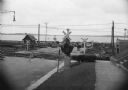
| Description: | View of a railroad crossing near Lake Monona. Men are on the standing on the road in the background, and other men are working along the railroad tracks. C... |
| Date: | |
|---|---|
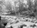
| Description: | Caption reads: "North Freedom, Wis. Broken dam at Mill Pond Park. The city was raising funds to rebuild dam and the Conservation Commission assisted." |

| Date: | 1948 |
|---|---|
| Description: | Groups of people are on four or five boats traveling on the Wisconsin River, with a shoreline behind them on the left. In the distance is the opposite shor... |
If you didn't find the material you searched for, our Library Reference Staff can help.
Call our reference desk at 608-264-6535 or email us at: