Filter: Categories of Wisconsin Historical Images
Filter: Creator Name of Newhouse, John
Filter: Subject of water
Filter: Categories of Wisconsin Historical Images
Filter: Creator Name of Newhouse, John
Filter: Subject of water

| Date: | 1956 |
|---|---|
| Description: | Aerial view over the eastern end of Lake Mendota, looking northeast. Maple Bluff is in the foreground and Truax Field is in the background. |

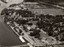
| Date: | 1956 |
|---|---|
| Description: | Aerial view looking south from a point over the Maple Bluff country club golf course (foreground). A new housing development in the mid-ground and Maple Bl... |

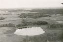
| Date: | 1957 |
|---|---|
| Description: | Aerial view of Yellowstone Lake and surrounding countryside. |

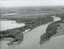
| Date: | 1955 |
|---|---|
| Description: | Aerial view of river and town from a military airplane. |

| Date: | |
|---|---|
| Description: | Aerial view of the southeast, with West Broadway and the South Beltline running through the image. Also shows Nob Hill restaurant, the Toki family farm and... |

| Date: | 1945 |
|---|---|
| Description: | Aerial view of Taliesin, Frank Lloyd Wright's residence and architectural school complex, with the Wisconsin River visible at the top. Taliesin is located... |

| Date: | 1955 |
|---|---|
| Description: | View down Monona Avenue, which is now Martin Luther King, Jr. Boulevard, toward Lake Monona. |
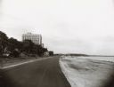
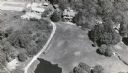
| Date: | 1957 |
|---|---|
| Description: | Law Park along Lake Monona, after filling in the shoreline to construct a road and parking lot. This is the current site of the Monona Terrace. |

| Date: | 1957 |
|---|---|
| Description: | Law Park along Lake Monona, before filling in the shoreline to construct a road and parking lot. |
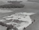
| Date: | 1955 |
|---|---|
| Description: | Aerial view of St. Benedict's convent, mother house, novitiate on the north shore of Lake Mendota (aka Fox Bluff), built in 1953. From 1959 - 1966 it was ... |
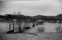
| Date: | 1945 |
|---|---|
| Description: | View of a footbridge over the Pine River. Boats are laying in the grass in the foreground. |
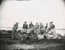
| Date: | 1948 |
|---|---|
| Description: | Destroying slot machines and other illegal gambling devices at Law Park. From L to R: John Roach, director of the state beverage and cigaret tax division; ... |
| Date: | 1955 |
|---|---|
| Description: | Aerial view of Castle Rock Dam on the Wisconsin River. |
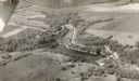
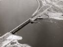
| Date: | 1958 |
|---|---|
| Description: | Aerial view of town. A bridge over the Mississippi River is in the foreground. |
If you didn't find the material you searched for, our Library Reference Staff can help.
Call our reference desk at 608-264-6535 or email us at: