Filter: Categories of Wisconsin Historical Images
Filter: Creator Name of Newhouse, John
Filter: Subject of transportation
Filter: Categories of Wisconsin Historical Images
Filter: Creator Name of Newhouse, John
Filter: Subject of transportation
| Date: | 1954 |
|---|---|
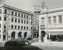
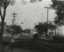
| Description: | A view of Fairchild Street from Mifflin Street. There is a sign on the side of the building on the right that reads: "Casey O'Brien." |

| Date: | 1955 |
|---|---|
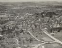
| Description: | Aerial view of river and town from a military airplane. |
| Date: | 1957 |
|---|---|
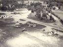
| Description: | Aerial view of the Baraboo Wisconsin Dells airport. |

| Date: | |
|---|---|
| Description: | Aerial view of the southeast, with West Broadway and the South Beltline running through the image. Also shows Nob Hill restaurant, the Toki family farm and... |

| Date: | 1955 |
|---|---|
| Description: | Aerial view of Mineral Point showing State Highway 23-39 under construction. |

| Date: | 1955 |
|---|---|
| Description: | An aerial view of Mineral Point showing the construction of State Highway 23-39. |
| Date: | 1955 |
|---|---|
| Description: | The intersection of Johnson and Broom Streets. |
| Date: | 1940 |
|---|---|
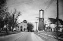
| Description: | View down a street in Sun Prairie, including a home, watertower, and church. |

| Date: | 1940 |
|---|---|
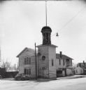
| Description: | Front exterior view of the Sun Prairie Public Library with a police car parked in front of it. |

| Date: | 1940 |
|---|---|
| Description: | Exterior view of a high school and the parking lot in front of it. |

| Date: | 1955 |
|---|---|
| Description: | A public bus crosses the bridge over a ravine on Lake Mendota Drive in Shorewood, looking east. |

| Date: | 1955 |
|---|---|
| Description: | Bridge over a ravine on Lake Mendota Drive in Shorewood Hills, looking west. |

| Date: | |
|---|---|
| Description: | Aerial view of a full Camp Randall Stadium during half-time of a football game. The band is on the field in formation to spell "UW." |

| Date: | 1940 |
|---|---|
| Description: | Exterior view of the Wisconsin Seed Company, Funk's Hybrid, with several automobiles parked beside it. |

| Date: | 1945 |
|---|---|
| Description: | Aerial view of Taliesin, Frank Lloyd Wright's residence and architectural school complex, with the Wisconsin River visible at the top. Taliesin is located... |

| Date: | 1955 |
|---|---|
| Description: | View down Monona Avenue, which is now Martin Luther King, Jr. Boulevard, toward Lake Monona. |
| Date: | 1957 |
|---|---|
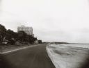
| Description: | Law Park along Lake Monona, after filling in the shoreline to construct a road and parking lot. This is the current site of the Monona Terrace. |
If you didn't find the material you searched for, our Library Reference Staff can help.
Call our reference desk at 608-264-6535 or email us at: