Filter: Categories of Wisconsin Historical Images
Filter: Creator Name of Newhouse, John
Filter: Subject of transportation
Filter: Subject of land
Filter: Categories of Wisconsin Historical Images
Filter: Creator Name of Newhouse, John
Filter: Subject of transportation
Filter: Subject of land

| Date: | 06 07 1954 |
|---|---|
| Description: | Aerial view of the Midvale neighborhood under construction showing the intersection of Midvale and Tokay Boulevards near the southwestern city limits of Ma... |
| Date: | |
|---|---|
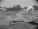
| Description: | Myrland's Sky Lodge, a vacation resort near Montello that boasted a private landing strip for pilots with small planes. The Piper Vagabond in the foregroun... |

| Date: | 1955 |
|---|---|
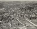
| Description: | Aerial view of Cross Plains, with countryside surrounding and hills on the horizon. |

| Date: | 1956 |
|---|---|
| Description: | Aerial view looking northeast from a point over the east end of Middleton, showing the west end of Lake Mendota (right mid-ground). Fox Bluff juts into the... |

| Date: | 1953 |
|---|---|
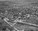
| Description: | Aerial view of Wonewoc with hills or bluffs in the foreground on the right. |

| Date: | 1955 |
|---|---|
| Description: | An aerial view of Mineral Point showing the construction of State Highway 23-39. |
| Date: | 1957 |
|---|---|
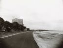
| Description: | Law Park along Lake Monona, after filling in the shoreline to construct a road and parking lot. This is the current site of the Monona Terrace. |
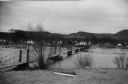
| Date: | 1945 |
|---|---|
| Description: | View of a footbridge over the Pine River. Boats are laying in the grass in the foreground. |

| Date: | 1959 |
|---|---|
| Description: | Aerial view of the Westgate Shopping Center under construction. |

| Date: | 1954 |
|---|---|
| Description: | Aerial view of the west side of Madison showing newly constructed homes and homes under construction featured in the Parade of Homes. The main road through... |

| Date: | 07 07 1954 |
|---|---|
| Description: | Aerial view of group of buildings on the north east campus of the University of Wisconsin, including the Historical Library, University Library, old Scienc... |

| Date: | |
|---|---|
| Description: | Aerial view over Monona Bay showing two railroads crossing in the center. Olin Park is on the top left. |

| Date: | 1968 |
|---|---|
| Description: | Air view of the University of Wisconsin-Madison campus looking north to Lake Mendota. Picnic Point, currently part of the Lakeshore Nature Preserve, and Ca... |
If you didn't find the material you searched for, our Library Reference Staff can help.
Call our reference desk at 608-264-6535 or email us at: