 Filter: Categories of Wisconsin Historical Images
Filter: Creator Name of Newhouse, John
Filter: Subject of transportation
Filter: Subject of central business districts
Filter: Categories of Wisconsin Historical Images
Filter: Creator Name of Newhouse, John
Filter: Subject of transportation
Filter: Subject of central business districts
| Date: | 1954 |
|---|---|
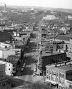
| Description: | Elevated view of State Street looking toward Bascom Hall and the University of Wisconsin-Madison campus from the Wisconsin State Capitol dome. |
| Date: | 1954 |
|---|---|
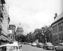
| Description: | A view down State Street looking towards the Wisconsin State Capitol. |
| Date: | 1954 |
|---|---|
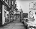
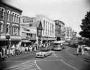
| Description: | King Street, looking past the Majestic Theater, with the Wisconsin State Capitol in the background. |

| Date: | 1958 |
|---|---|
| Description: | Aerial view of the Wisconsin State Capitol and surrounding area. The view is looking northwest, with King Street on the bottom right, and S. Hamilton Stree... |
| Date: | 1948 |
|---|---|
| Description: | Exterior view from street of O.N. Falk's Drug Store, on Main Street. |
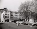
| Date: | 1954 |
|---|---|
| Description: | View of the corner of Carroll and West Main Streets downtown. The Park Hotel occupies the large building. The Prescription Pharmacy, the Park Hotel Barber ... |
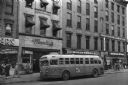
| Date: | 1955 |
|---|---|
| Description: | Bus traveling down Mifflin Street on Capitol Square. Moseleys, Woldenbergs and Walgreen's Drugs are on the right. |

| Date: | 1955 |
|---|---|
| Description: | Air view of University Avenue at Midvale Boulevard. |
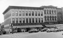
| Date: | 1954 |
|---|---|
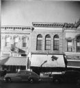
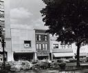
| Description: | S.S. Kresge storefront and Miller's clothing store on Main Street. |
| Date: | 1954 |
|---|---|
| Description: | View looking west down Mifflin Street showing the old City Hall, the Parkway Theater, and Manchesters Department Store. Automobiles are parked at an angle ... |
| Date: | 1952 |
|---|---|
| Description: | Slightly elevated view of a parade on the Capitol Square, celebrating a visit by Adlai Stevenson, Democratic candidate for President. |
| Date: | 1950 |
|---|---|
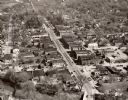
| Description: | Aerial view of the main street of town. |

| Date: | 1953 |
|---|---|
| Description: | Aerial view looking southeast over Madison's near east side. The Eagles Club at 1236 Jenifer Street / 1221 Williamson Street is under construction in the ... |

| Date: | 1955 |
|---|---|
| Description: | Aerial view of the central traffic loop and Johnson Street expressway. |

| Date: | 1955 |
|---|---|
| Description: | Aerial view of the Illinois central route. The UW Fieldhouse is visible in the lower right of the image. |

| Date: | 1953 |
|---|---|
| Description: | An aerial view of Wonewoc showing central businesses and a railroad. |

| Date: | 1955 |
|---|---|
| Description: | Aerial view of Mineral Point showing State Highway 23-39 under construction. |
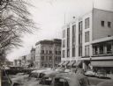
| Date: | 1954 |
|---|---|
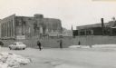
| Description: | The intersection of Mifflin Street and Wisconsin Avenue after the old City Hall (1858-1954) and Fuller Opera House had been torn down. |
| Date: | 1954 |
|---|---|
| Description: | Pinckney Street, near the corner of East Washington Avenue. To the left is a bank building, in the center a shoe store, and on the right a theatre. |

| Date: | 1960 |
|---|---|
| Description: | View of a state office building, and, at far right, the City-County building. |
If you didn't find the material you searched for, our Library Reference Staff can help.
Call our reference desk at 608-264-6535 or email us at: