 Filter: Categories of Wisconsin Historical Images
Filter: Creator Name of Newhouse, John
Filter: Subject of streets
Filter: Subject of dwellings
Filter: Categories of Wisconsin Historical Images
Filter: Creator Name of Newhouse, John
Filter: Subject of streets
Filter: Subject of dwellings

| Date: | 1956 |
|---|---|
| Description: | Aerial view of the Chicago, Milwaukee, and St. Paul Railroad station, roundhouse, and yard at the intersection of West Washington Avenue (across lower left... |
| Date: | 1957 |
|---|---|
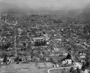
| Description: | Aerial view of town and the surrounding countryside. |

| Date: | 1953 |
|---|---|
| Description: | Aerial view looking southeast over Madison's near east side. The Eagles Club at 1236 Jenifer Street / 1221 Williamson Street is under construction in the ... |

| Date: | 1950 |
|---|---|
| Description: | View across street towards the U.S. Post Office, with a Jefferson Community Fire Department truck parked at the curb in front. |
| Date: | 1954 |
|---|---|
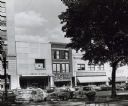
| Description: | Pinckney Street, near the corner of East Washington Avenue. To the left is a bank building, in the center a shoe store, and on the right a theatre. |

| Date: | |
|---|---|
| Description: | View of two similar houses at 188 and 120 West Wilson Street from across the street. |

| Date: | 1955 |
|---|---|
| Description: | An aerial view of Middleton. In the foreground is a baseball field, and beyond are houses, woods, fields, and Lake Mendota. |

| Date: | 1956 |
|---|---|
| Description: | Aerial view of residential homes, farmland and streets. |

| Date: | 1955 |
|---|---|
| Description: | Aerial view, looking west from over Hoyt Park toward Midvale Boulevard. |

| Date: | 1954 |
|---|---|
| Description: | Aerial view of the west side of Madison showing newly constructed homes and homes under construction featured in the Parade of Homes. The main road through... |

| Date: | 1945 |
|---|---|
| Description: | An aerial view, looking northeast, that includes the intersection at Atwood and Fair Oaks Avenues. Elmside Circle Park is on the bottom left. The Madison-K... |

| Date: | 1968 |
|---|---|
| Description: | Aerial view looking southwest, with Lake Mendota at right and East Gorham Street running from the bottom left corner. Lincoln School is in the foreground, ... |

| Date: | 1962 |
|---|---|
| Description: | Air view in winter of the Triangle Redevelopment Project looking east with Regent Street running along the left edge, W. Washington Avenue along the top, a... |

| Date: | 03 1962 |
|---|---|
| Description: | Aerial view with beginning of construction on Sellery Hall on the block bounded by Park, West Johnson, Murray, and West Dayton Streets. Park Street runs fr... |

| Date: | 1968 |
|---|---|
| Description: | Air view of the University of Wisconsin-Madison campus looking north to Lake Mendota. Picnic Point, currently part of the Lakeshore Nature Preserve, and Ca... |

| Date: | 1962 |
|---|---|
| Description: | Aerial view of the Hilldale Shopping Center and environs. Anchor store is Gimbels. N. Midvale Boulevard runs left to right. The State Department of Transpo... |

| Date: | 1967 |
|---|---|
| Description: | Air view looking north toward Lake Mendota. The intersection of West Washington Ave. and S. Park Street is at bottom center. The Triangle Redevelopment Pro... |

| Date: | 1960 |
|---|---|
| Description: | Air view focused on the Greenbush neighborhood of Madison prior to its demolition for the Triangle Redevelopment Project. Monona Bay and Brittingham Park a... |
If you didn't find the material you searched for, our Library Reference Staff can help.
Call our reference desk at 608-264-6535 or email us at:

