Filter: Categories of Wisconsin Historical Images
Filter: Creator Name of Newhouse, John
Filter: Subject of intellectual life
Filter: Categories of Wisconsin Historical Images
Filter: Creator Name of Newhouse, John
Filter: Subject of intellectual life

| Date: | 1956 |
|---|---|
| Description: | Aerial view of upper campus of the University of Wisconsin-Madison with Lake Mendota. |
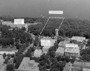
| Date: | 1958 |
|---|---|
| Description: | Aerial view of upper campus on the University of Wisconsin-Madison. Typewritten labels mark the location of Elizabeth Waters Hall, New Commerce Building, L... |
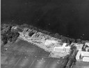
| Date: | 1958 |
|---|---|
| Description: | Aerial view of the construction of the lakeshore dormitories, the recreation facilities and Lake Mendota on the University of Wisconsin Madison campus. |

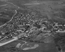
| Date: | 1955 |
|---|---|
| Description: | Aerial view of town, with the Baraboo River. |

| Date: | 1945 |
|---|---|
| Description: | Aerial view of the "powder storage area" of the Badger Ordnance Plant. |
| Date: | 1957 |
|---|---|
| Description: | Aerial view including many buildings and a baseball diamond. |
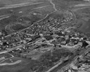
| Date: | 1957 |
|---|---|
| Description: | Air view of town, including multiple buildings and a cemetery. |

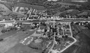
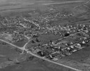
| Date: | 1955 |
|---|---|
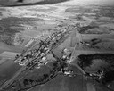
| Description: | Aerial view of Cross Plains, with countryside surrounding and hills on the horizon. |

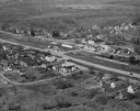
| Date: | 1950 |
|---|---|
| Description: | Aerial view of main street. There is a bridge with a stream flowing under it in the foreground. |
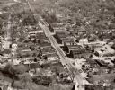
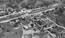
| Date: | 1950 |
|---|---|
| Description: | Aerial view of the main street of town. |
If you didn't find the material you searched for, our Library Reference Staff can help.
Call our reference desk at 608-264-6535 or email us at: