Filter: Categories of Wisconsin Historical Images
Filter: Creator Name of Newhouse, John
Filter: Subject of intellectual life
Filter: Subject of neighborhoods
Filter: Categories of Wisconsin Historical Images
Filter: Creator Name of Newhouse, John
Filter: Subject of intellectual life
Filter: Subject of neighborhoods

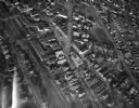
| Date: | 06 07 1954 |
|---|---|
| Description: | Aerial view of the Midvale neighborhood under construction showing the intersection of Midvale and Tokay Boulevards near the southwestern city limits of Ma... |

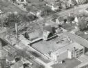
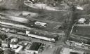
| Date: | 1956 |
|---|---|
| Description: | Aerial view of the Chicago, Milwaukee, and St. Paul Railroad station, roundhouse, and yard at the intersection of West Washington Avenue (across lower left... |

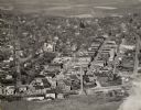
| Date: | 1955 |
|---|---|
| Description: | Aerial view of Atwood Avenue, looking west towards Winnebago Street and "Schenk's Corners." |

| Date: | 1953 |
|---|---|
| Description: | Aerial view looking southeast over Madison's near east side. The Eagles Club at 1236 Jenifer Street / 1221 Williamson Street is under construction in the ... |

| Date: | 1953 |
|---|---|
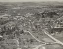
| Description: | Aerial view of Wonewoc with hills or bluffs in the foreground on the right. |

| Date: | 1953 |
|---|---|
| Description: | An aerial view of Wonewoc showing central businesses and a railroad. |

| Date: | |
|---|---|
| Description: | Aerial view of the southeast, with West Broadway and the South Beltline running through the image. Also shows Nob Hill restaurant, the Toki family farm and... |

| Date: | 1955 |
|---|---|
| Description: | Aerial view of Mineral Point showing State Highway 23-39 under construction. |

| Date: | |
|---|---|
| Description: | Aerial view of the Crestwood neighborhood. |

| Date: | |
|---|---|
| Description: | Aerial view of a full Camp Randall Stadium during half-time of a football game. The band is on the field in formation to spell "UW." |
| Date: | 11 1958 |
|---|---|
| Description: | The St. Bernard's Catholic Church during construction. The church was completed in March of 1959. |
| Date: | 1954 |
|---|---|
| Description: | Aerial view of the Gonstead residence, owned by a well-known chiropractor and designed by Herb Fritz, architect, a student of Frank Lloyd Wright. |

| Date: | |
|---|---|
| Description: | Aerial view of Union Corners intersection of East Washington Avenue, Milwaukee Street and North Street looking north. The Rayovac building is in the foregr... |

| Date: | 1956 |
|---|---|
| Description: | Aerial view of St. Mary's Hospital and the surrounding residential neighborhoods. |
| Date: | |
|---|---|
| Description: | Aerial view of University Avenue near the Veteran's Administration Hospital. The J.S. Timlin Lumber Company is along University Avenue. |

| Date: | 1955 |
|---|---|
| Description: | Aerial view of Schenk's Corners where Atwood Avenue and Winnebago Street cross, looking north west toward East Washington Avenue. ... |
| Date: | 1945 |
|---|---|
| Description: | Aerial view of Schenk's Corners looking east showing the intersection of Atwood Avenue and Winnebago Street. |

| Date: | 1956 |
|---|---|
| Description: | Aerial view of Schenk's Corners where Atwood Avenue and Winnebago Street cross, looking north east. |
If you didn't find the material you searched for, our Library Reference Staff can help.
Call our reference desk at 608-264-6535 or email us at: