 Filter: Categories of Wisconsin Historical Images
Filter: Creator Name of Newhouse, John
Filter: Subject of human settlements
Filter: Categories of Wisconsin Historical Images
Filter: Creator Name of Newhouse, John
Filter: Subject of human settlements

| Date: | 1954 |
|---|---|
| Description: | Elevated view looking southwest over tree-tops from Bascom Hall. Sterling Hall is on the left. The spire of the First Congregational Church is visible in t... |
| Date: | 1954 |
|---|---|
| Description: | View from roof top of lower campus at the University of Wisconsin-Madison. Wisconsin Historical Society is in left foreground and Science Hall is visible b... |
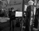
| Date: | 1947 |
|---|---|
| Description: | A gas station attendant puts on his coat outside the White Grocery and Filling Station in Madison. A sign near the pumps reads, "Please Give Me Ten Seconds... |
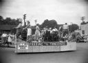
| Date: | 1955 |
|---|---|
| Description: | The Brooklyn Grange parade float in a Labor Day parade. Men and women on the float mimic various household and recreational activities. |

| Date: | 1956 |
|---|---|
| Description: | Aerial view of Wisconsin General Hospital. |

| Date: | 1956 |
|---|---|
| Description: | The old YMCA building in the initial stage of demolition. |

| Date: | 1954 |
|---|---|
| Description: | View from atop a building across Wisconsin Avenue of the Fuller Opera House during its demolition. |

| Date: | 1955 |
|---|---|
| Description: | Aerial view of Schenk's Corners where Atwood Avenue and Winnebago Street cross, looking north west toward East Washington Avenue. ... |
| Date: | 1945 |
|---|---|
| Description: | Aerial view of Schenk's Corners looking east showing the intersection of Atwood Avenue and Winnebago Street. |

| Date: | 1956 |
|---|---|
| Description: | Aerial view of Schenk's Corners where Atwood Avenue and Winnebago Street cross, looking north east. |

| Date: | 1955 |
|---|---|
| Description: | An aerial view of Middleton. In the foreground is a baseball field, and beyond are houses, woods, fields, and Lake Mendota. |

| Date: | 07 15 1958 |
|---|---|
| Description: | Aerial view of Eagle Heights Farm, Eagle Heights Woods and part of Lake Mendota. Sites labeled on the image are Eagle Heights, Tent Colony, Apartment Site,... |

| Date: | 04 1954 |
|---|---|
| Description: | Rollohome mobile home as received from the factory and parked at Reynolds Transfer and Storage Co. on E. Main Street prior to being moved to the State Hist... |
| Date: | 1965 |
|---|---|
| Description: | Aerial view of the UW-Madison campus near University Bay in winter. Labels are pasted to the print to indicate Elm Dr., the gym, Camp Randall Stadium, the ... |

| Date: | 1959 |
|---|---|
| Description: | Aerial view of the Westgate Shopping Center under construction. |

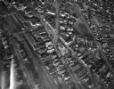
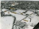
| Date: | 1956 |
|---|---|
| Description: | Aerial view of residential homes, farmland and streets. |

| Date: | 06 1960 |
|---|---|
| Description: | Model standing in front of 3209 Kingston Drive, a demonstration residence at the 1960 “Parade of Homes” promotional event. |
| Date: | 1960 |
|---|---|
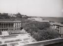
| Description: | View looking down on Pinckney Street, with a section of Capitol park, from the Belmont Hotel. |

| Date: | 1955 |
|---|---|
| Description: | Aerial view, looking west from over Hoyt Park toward Midvale Boulevard. |
If you didn't find the material you searched for, our Library Reference Staff can help.
Call our reference desk at 608-264-6535 or email us at:
