 Filter: Categories of Wisconsin Historical Images
Filter: Creator Name of Newhouse, John
Filter: Subject of human settlements
Filter: Categories of Wisconsin Historical Images
Filter: Creator Name of Newhouse, John
Filter: Subject of human settlements
| Date: | 1958 |
|---|---|
| Description: | Aerial view of Orchard Ridge School, at 5602 Russett Road. |
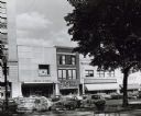
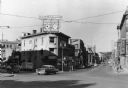
| Date: | 1954 |
|---|---|
| Description: | Pinckney Street, near the corner of East Washington Avenue. To the left is a bank building, in the center a shoe store, and on the right a theatre. |

| Date: | 1955 |
|---|---|
| Description: | East Washington Avenue near Union Corners when first reopened after widening in 1955. Several vehicles are on the road. |
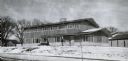
| Date: | 1956 |
|---|---|
| Description: | A wintery view of the rectory of the Queen of Peace church lacated at 418 Holly Avenue. |

| Date: | |
|---|---|
| Description: | View of the Ragatz home in the Shorewood Hills neighborhood of Madison. |

| Date: | 1956 |
|---|---|
| Description: | Aerial view of St. Mary's Hospital and the surrounding residential neighborhoods. |
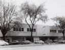
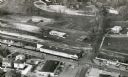
| Date: | 1954 |
|---|---|
| Description: | View of the Sears-Roebuck store on East Washington Avenue. The portion of East Washington in front of the store is full of parked automobiles. |

| Date: | 1956 |
|---|---|
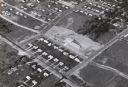
| Description: | Aerial view of the Sears-Roebuck department store on East Washington Avenue and its surrounding parking lots. |

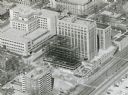
| Date: | 1958 |
|---|---|
| Description: | An aerial view of the construction of a new wing on a state office building. Automobiles are parked in a log along Lake Monona. |

| Date: | 1960 |
|---|---|
| Description: | View of a state office building, and, at far right, the City-County building. |

| Date: | 1954 |
|---|---|
| Description: | An aerial view of the State Office Building, 1 West Wilson Street. Also shows Olin Terrace, Madison Club and the United States Post Office. |
| Date: | 1958 |
|---|---|
| Description: | An aerial view of the contruction of a new wing on the State Office Building. |

| Date: | 1954 |
|---|---|
| Description: | View from intersection towards the Wisconsin Building, which was built in 1901. Located at the intersection of State and Carroll Streets, at 102 State Stre... |
| Date: | 1958 |
|---|---|
| Description: | View of State Street, looking west. Across the intersection on the corner is Sandra's Millinery at 101 State Street. |
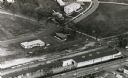
| Date: | |
|---|---|
| Description: | Aerial view of University Avenue near the Veteran's Administration Hospital. The J.S. Timlin Lumber Company is along University Avenue. |
| Date: | |
|---|---|
| Description: | Aerial view of University Avenue near the Veteran's Administration Hospital. At the bottom is the J.S. Timlin Lumber Company. |

| Date: | 1955 |
|---|---|
| Description: | Elevated view looking west at Washington School, located at 217 North Broom Street. From the early 1940's until its demolition in 1957, the school was used... |

| Date: | 1950 |
|---|---|
| Description: | Looking northeast, towards the Wisconsin State Capitol from West Washington Avenue at its intersection with 503 Regent Street. At the left is the Hoffman F... |

| Date: | 1955 |
|---|---|
| Description: | View of the Wisconsin State Capitol from the intersection of Regent Street and West Washington Avenue. |
If you didn't find the material you searched for, our Library Reference Staff can help.
Call our reference desk at 608-264-6535 or email us at:
