 Filter: Categories of Wisconsin Historical Images
Filter: Creator Name of Newhouse, John
Filter: Subject of dwellings
Filter: Subject of learning and scholarship
Filter: Categories of Wisconsin Historical Images
Filter: Creator Name of Newhouse, John
Filter: Subject of dwellings
Filter: Subject of learning and scholarship
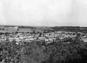
| Date: | 1954 |
|---|---|
| Description: | Elevated view of lower Sunset Village looking northwest from Sunset Point. University Hill Farm is on the left and Shorewood Hills is on the right. |
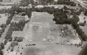
| Date: | 1957 |
|---|---|
| Description: | Aerial view of Campion College of the Sacred Heart. |

| Date: | 1956 |
|---|---|
| Description: | Aerial view over University Avenue of the University of Wisconsin-Madison campus, including University farm in the upper middle. The shoreline of Lake Mend... |
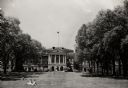
| Date: | 1954 |
|---|---|
| Description: | View of Bascom Hall from Bascom Hill (formerly Main Hall) on the University of Wisconsin-Madison campus. A few people are sitting on the lawn in front of ... |
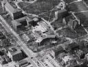
| Date: | 1958 |
|---|---|
| Description: | Aerial view of Chadbourne Hall under construction on the University of Wisconsin-Madison campus. The new building is at the corner of Park Street and Unive... |
| Date: | 1958 |
|---|---|
| Description: | Aerial view of Chadbourne Hall under construction on the University of Wisconsin-Madison campus at the corner of Park Street and University Avenue. Music H... |
| Date: | 1958 |
|---|---|
| Description: | Aerial View of Eagle Heights Apartments, built especially for married students' housing, under construction on the University of Wisconsin-Madison campus. ... |

| Date: | 1956 |
|---|---|
| Description: | Memorial Library, Armory (Red Gym or Old Red), and University of Wisconsin Boathouse from across mall on the lower campus of the University of Wisconsin-Ma... |

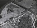
| Date: | 07 15 1958 |
|---|---|
| Description: | Aerial view of Eagle Heights Farm, Eagle Heights Woods and part of Lake Mendota. Sites labeled on the image are Eagle Heights, Tent Colony, Apartment Site,... |

| Date: | 06 1960 |
|---|---|
| Description: | Aerial view looking northwest showing an area to be redeveloped into high-rise dormitories. Lake Mendota and Bascom Woods can be seen at the top. Universit... |

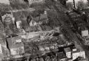
| Date: | 1965 |
|---|---|
| Description: | Air view of the west end of University of Wisconsin-Madison campus with U.W. Hospital and U.W. athletic fields at top. Campus Drive and University Avenue r... |

| Date: | 1968 |
|---|---|
| Description: | Air view of the University of Wisconsin-Madison campus looking north to Lake Mendota. Picnic Point, currently part of the Lakeshore Nature Preserve, and Ca... |
If you didn't find the material you searched for, our Library Reference Staff can help.
Call our reference desk at 608-264-6535 or email us at: