Filter: Categories of Wisconsin Historical Images
Filter: Creator Name of Newhouse, John
Filter: Subject of dwellings
Filter: Subject of cities and towns
Filter: Categories of Wisconsin Historical Images
Filter: Creator Name of Newhouse, John
Filter: Subject of dwellings
Filter: Subject of cities and towns

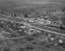
| Date: | 06 07 1954 |
|---|---|
| Description: | Aerial view of the Midvale neighborhood under construction showing the intersection of Midvale and Tokay Boulevards near the southwestern city limits of Ma... |

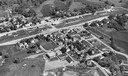
| Date: | 1955 |
|---|---|
| Description: | Aerial view of Midvale neighborhood under construction near Madison's southwestern city limits. The view is focused on the area bounded by Tokay Boulevard,... |

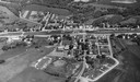
| Date: | 1956 |
|---|---|
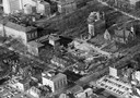
| Description: | Aerial view of the Chicago, Milwaukee, and St. Paul Railroad station, roundhouse, and yard at the intersection of West Washington Avenue (across lower left... |
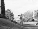
| Date: | 1955 |
|---|---|
| Description: | A man who does odd jobs around his neighborhood mows a banked lawn. |

| Date: | 1950 |
|---|---|
| Description: | Mounted on a ladder, a man is poised to empty a bucket onto the open umbrella of a man sitting on a sidewalk bench. |
| Date: | 1957 |
|---|---|
| Description: | Aerial view of the construction of Chadbourne Hall, lower Bascom Hill on the University of Wisconsin campus. |
| Date: | 1954 |
|---|---|
| Description: | Elevated view of lower Sunset Village looking northwest from Sunset Point. University Hill Farm is on the left and Shorewood Hills is on the right. |
| Date: | 1957 |
|---|---|
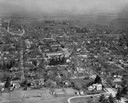
| Description: | Aerial view including many buildings and a baseball diamond. |
| Date: | 1957 |
|---|---|
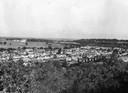
| Description: | Aerial view of town and the surrounding countryside. |

| Date: | 1955 |
|---|---|
| Description: | Aerial view of Atwood Avenue, looking west towards Winnebago Street and "Schenk's Corners." |

| Date: | 1953 |
|---|---|
| Description: | Aerial view looking southeast over Madison's near east side. The Eagles Club at 1236 Jenifer Street / 1221 Williamson Street is under construction in the ... |

| Date: | 1950 |
|---|---|
| Description: | View across street towards the U.S. Post Office, with a Jefferson Community Fire Department truck parked at the curb in front. |

| Date: | 1955 |
|---|---|
| Description: | Doctors Lindley and John T. Sprague house, 109 East Johnson Street. |
| Date: | 1940 |
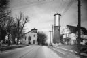
|---|---|
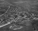
| Description: | View down a street in Sun Prairie, including a home, watertower, and church. |
If you didn't find the material you searched for, our Library Reference Staff can help.
Call our reference desk at 608-264-6535 or email us at: