Filter: Categories of Wisconsin Historical Images
Filter: Creator Name of Newhouse, John
Filter: Subject of cities and towns
Filter: Categories of Wisconsin Historical Images
Filter: Creator Name of Newhouse, John
Filter: Subject of cities and towns
| Date: | 1945 |
|---|---|
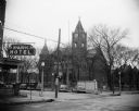
| Description: | Exterior view of the Richland County Courthouse, across the street from the Park Hotel whose sign is visible on the left-hand side of the image. |

| Date: | 1955 |
|---|---|
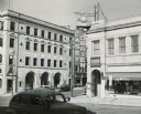
| Description: | Elevated view of Capitol Square, looking northwest up Carroll Street at its intersection with Main Street. |

| Date: | 1957 |
|---|---|
| Description: | Aerial view of Yellowstone Lake and surrounding countryside. |

| Date: | 1957 |
|---|---|
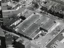
| Description: | An aerial view of Edgewood College and Schools. |

| Date: | 1953 |
|---|---|
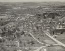
| Description: | Aerial view of Wonewoc with hills or bluffs in the foreground on the right. |

| Date: | 1957 |
|---|---|
| Description: | An aerial view of Edgewood College and Schools. |

| Date: | 1953 |
|---|---|
| Description: | An aerial view of Wonewoc showing central businesses and a railroad. |

| Date: | 1950 |
|---|---|
| Description: | View across street towards the U.S. Post Office, with a Jefferson Community Fire Department truck parked at the curb in front. |
| Date: | 1954 |
|---|---|
| Description: | A view of Fairchild Street from Mifflin Street. There is a sign on the side of the building on the right that reads: "Casey O'Brien." |

| Date: | 1955 |
|---|---|
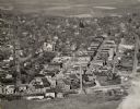
| Description: | Aerial view of river and town from a military airplane. |
| Date: | 1957 |
|---|---|
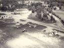
| Description: | Aerial view of the Baraboo Wisconsin Dells airport. |

| Date: | |
|---|---|
| Description: | Aerial view of the southeast, with West Broadway and the South Beltline running through the image. Also shows Nob Hill restaurant, the Toki family farm and... |

| Date: | 1955 |
|---|---|
| Description: | Aerial view of Mineral Point showing State Highway 23-39 under construction. |

| Date: | 1955 |
|---|---|
| Description: | An aerial view of Mineral Point showing the construction of State Highway 23-39. |
If you didn't find the material you searched for, our Library Reference Staff can help.
Call our reference desk at 608-264-6535 or email us at: