 Filter: Categories of Wisconsin Historical Images
Filter: Creator Name of Newhouse, John
Filter: Subject of central business districts
Filter: Categories of Wisconsin Historical Images
Filter: Creator Name of Newhouse, John
Filter: Subject of central business districts
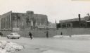
| Date: | 1954 |
|---|---|
| Description: | The intersection of Mifflin Street and Wisconsin Avenue after the old City Hall (1858-1954) and Fuller Opera House had been torn down. |
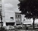
| Date: | 1954 |
|---|---|
| Description: | Pinckney Street, near the corner of East Washington Avenue. To the left is a bank building, in the center a shoe store, and on the right a theatre. |

| Date: | 1960 |
|---|---|
| Description: | View of a state office building, and, at far right, the City-County building. |

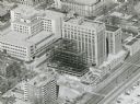
| Date: | 1954 |
|---|---|
| Description: | An aerial view of the State Office Building, 1 West Wilson Street. Also shows Olin Terrace, Madison Club and the United States Post Office. |
| Date: | 1958 |
|---|---|
| Description: | An aerial view of the contruction of a new wing on the State Office Building. |

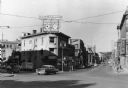
| Date: | 1954 |
|---|---|
| Description: | View from intersection towards the Wisconsin Building, which was built in 1901. Located at the intersection of State and Carroll Streets, at 102 State Stre... |
| Date: | 1958 |
|---|---|
| Description: | View of State Street, looking west. Across the intersection on the corner is Sandra's Millinery at 101 State Street. |

| Date: | 1954 |
|---|---|
| Description: | View of Capitol Square and its surrounding buildings. To the left is the Washington Building located on the site of the old "Journal Block" and on the righ... |

| Date: | 09 1954 |
|---|---|
| Description: | Elevated view of Wisconsin Avenue from the Wisconsin State Capitol balcony. At the lower left, the demolition of old City Hall is in progress, which began ... |

| Date: | 1954 |
|---|---|
| Description: | Looking northwest down Wisconsin Avenue from the Wisconsin State Capitol dome. Mifflin Street is visible in the foreground, while in the center of the phot... |

| Date: | 1955 |
|---|---|
| Description: | Aerial view of Schenk's Corners where Atwood Avenue and Winnebago Street cross, looking north west toward East Washington Avenue. ... |
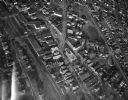
| Date: | 1945 |
|---|---|
| Description: | Aerial view of Schenk's Corners looking east showing the intersection of Atwood Avenue and Winnebago Street. |

| Date: | 1956 |
|---|---|
| Description: | Aerial view of Schenk's Corners where Atwood Avenue and Winnebago Street cross, looking north east. |

| Date: | 1945 |
|---|---|
| Description: | An aerial view, looking northeast, that includes the intersection at Atwood and Fair Oaks Avenues. Elmside Circle Park is on the bottom left. The Madison-K... |
| Date: | 1963 |
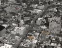
|---|---|
| Description: | Aerial view of downtown Madison focused on Mifflin and Fairchild Streets with the site of the new Madison Public Library marked. Mifflin Street runs diagon... |
If you didn't find the material you searched for, our Library Reference Staff can help.
Call our reference desk at 608-264-6535 or email us at: