Filter: Categories of Wisconsin Historical Images
Filter: Creator Name of Newhouse, John
Filter: Subject of botany
Filter: Subject of roads
Filter: Categories of Wisconsin Historical Images
Filter: Creator Name of Newhouse, John
Filter: Subject of botany
Filter: Subject of roads

| Date: | 1956 |
|---|---|
| Description: | Aerial view of the South Park Street interchange. |

| Date: | 1945 |
|---|---|
| Description: | Aerial view of the "powder storage area" of the Badger Ordnance Plant. |

| Date: | 1955 |
|---|---|
| Description: | Aerial view of Cross Plains, with countryside surrounding and hills on the horizon. |

| Date: | 1956 |
|---|---|
| Description: | Aerial view looking northeast from a point over the east end of Middleton, showing the west end of Lake Mendota (right mid-ground). Fox Bluff juts into the... |

| Date: | 1955 |
|---|---|
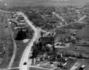
| Description: | Aerial view of Atwood Avenue, looking west towards Winnebago Street and "Schenk's Corners." |

| Date: | 1953 |
|---|---|
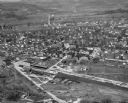
| Description: | Aerial view of Wonewoc with hills or bluffs in the foreground on the right. |
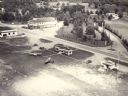
| Date: | 1957 |
|---|---|
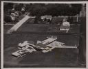
| Description: | Aerial view of the Baraboo Wisconsin Dells airport. |

| Date: | 1945 |
|---|---|
| Description: | Aerial view of Taliesin, Frank Lloyd Wright's residence and architectural school complex, with the Wisconsin River visible at the top. Taliesin is located... |
| Date: | 1957 |
|---|---|
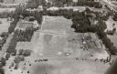
| Description: | Aerial view of various buildings and roads. |
| Date: | 1954 |
|---|---|
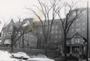
| Description: | Methodist Hospital, from West Washington Avenue. |
| Date: | 1954 |
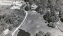
|---|---|
| Description: | Aerial view of the Gonstead residence, owned by a well-known chiropractor and designed by Herb Fritz, architect, a student of Frank Lloyd Wright. |
| Date: | 1957 |
|---|---|
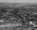
| Description: | Aerial view of downtown, including park, church, and stores. |
| Date: | 1957 |
|---|---|
| Description: | Aerial view of Campion College of the Sacred Heart. |

| Date: | 1957 |
|---|---|
| Description: | Aerial view of town including water tower, city streets, houses, and other buildings. |

| Date: | 1955 |
|---|---|
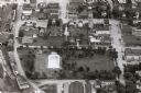
| Description: | Elevated view looking west at Washington School, located at 217 North Broom Street. From the early 1940's until its demolition in 1957, the school was used... |
If you didn't find the material you searched for, our Library Reference Staff can help.
Call our reference desk at 608-264-6535 or email us at: