 Filter: Categories of Wisconsin Historical Images
Filter: Creator Name of Newhouse, John
Filter: Subject of botany
Filter: Subject of neighborhoods
Filter: Categories of Wisconsin Historical Images
Filter: Creator Name of Newhouse, John
Filter: Subject of botany
Filter: Subject of neighborhoods

| Date: | 1956 |
|---|---|
| Description: | Aerial view of the Chicago, Milwaukee, and St. Paul Railroad station, roundhouse, and yard at the intersection of West Washington Avenue (across lower left... |
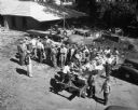
| Date: | 1950 |
|---|---|
| Description: | People gather around a table of food for the First Unitarian Society's "Work Day". The building was designed by Frank Lloyd Wright and some of the construc... |

| Date: | 1955 |
|---|---|
| Description: | Aerial view of Atwood Avenue, looking west towards Winnebago Street and "Schenk's Corners." |

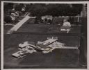
| Date: | 1953 |
|---|---|
| Description: | Aerial view looking southeast over Madison's near east side. The Eagles Club at 1236 Jenifer Street / 1221 Williamson Street is under construction in the ... |

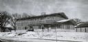
| Date: | 1955 |
|---|---|
| Description: | Exterior view of Central High School with cars parked in front. |

| Date: | 1953 |
|---|---|
| Description: | Aerial view of Wonewoc with hills or bluffs in the foreground on the right. |

| Date: | 1955 |
|---|---|
| Description: | Doctors Lindley and John T. Sprague house, 109 East Johnson Street. |
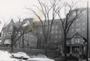
| Date: | 1954 |
|---|---|
| Description: | Methodist Hospital, from West Washington Avenue. |
| Date: | 1954 |
|---|---|
| Description: | Aerial view of the Gonstead residence, owned by a well-known chiropractor and designed by Herb Fritz, architect, a student of Frank Lloyd Wright. |
| Date: | 1956 |
|---|---|
| Description: | A wintery view of the rectory of the Queen of Peace church lacated at 418 Holly Avenue. |

| Date: | |
|---|---|
| Description: | View of the Ragatz home in the Shorewood Hills neighborhood of Madison. |

| Date: | 1955 |
|---|---|
| Description: | Elevated view looking west at Washington School, located at 217 North Broom Street. From the early 1940's until its demolition in 1957, the school was used... |

| Date: | 1955 |
|---|---|
| Description: | Aerial view of Schenk's Corners where Atwood Avenue and Winnebago Street cross, looking north west toward East Washington Avenue. ... |

| Date: | 1956 |
|---|---|
| Description: | Aerial view of Schenk's Corners where Atwood Avenue and Winnebago Street cross, looking north east. |

| Date: | 1955 |
|---|---|
| Description: | Aerial view, looking west from over Hoyt Park toward Midvale Boulevard. |

| Date: | 1945 |
|---|---|
| Description: | An aerial view, looking northeast, that includes the intersection at Atwood and Fair Oaks Avenues. Elmside Circle Park is on the bottom left. The Madison-K... |

| Date: | |
|---|---|
| Description: | View across intersection towards several people standing outside a building that is partially demolished. A nearby sign advertises the Union House. Caption... |

| Date: | |
|---|---|
| Description: | Caption reads: "Madison, Wis. Air view of football practice field and stadium of the University of Wisconsin." |
If you didn't find the material you searched for, our Library Reference Staff can help.
Call our reference desk at 608-264-6535 or email us at:

