Filter: Categories of Wisconsin Historical Images
Filter: Creator Name of Newhouse, John
Filter: Subject of architecture
Filter: Subject of intellectual life
Filter: Subject of dwellings
Filter: Categories of Wisconsin Historical Images
Filter: Creator Name of Newhouse, John
Filter: Subject of architecture
Filter: Subject of intellectual life
Filter: Subject of dwellings

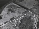
| Date: | 1955 |
|---|---|
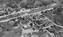
| Description: | Aerial view of Midvale neighborhood under construction near Madison's southwestern city limits. The view is focused on the area bounded by Tokay Boulevard,... |
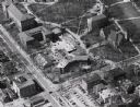
| Date: | 1957 |
|---|---|
| Description: | Aerial view of the construction of Chadbourne Hall, lower Bascom Hill on the University of Wisconsin campus. |
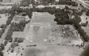
| Date: | 1957 |
|---|---|
| Description: | Aerial view including many buildings and a baseball diamond. |

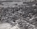
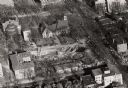
| Date: | 1953 |
|---|---|
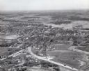
| Description: | Aerial view looking southeast over Madison's near east side. The Eagles Club at 1236 Jenifer Street / 1221 Williamson Street is under construction in the ... |

| Date: | |
|---|---|
| Description: | Aerial view of a full Camp Randall Stadium during half-time of a football game. The band is on the field in formation to spell "UW." |

| Date: | 1945 |
|---|---|
| Description: | Aerial view of Taliesin, Frank Lloyd Wright's residence and architectural school complex, with the Wisconsin River visible at the top. Taliesin is located... |
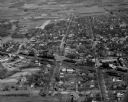
| Date: | 1957 |
|---|---|
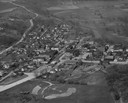
| Description: | Aerial view of town with multiple buildings and a water tower visible in the background. |
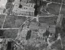
| Date: | 1957 |
|---|---|
| Description: | Aerial view of Campion College of the Sacred Heart. |

| Date: | 1957 |
|---|---|
| Description: | Aerial view of town including water tower, city streets, houses, and other buildings. |
| Date: | 1957 |
|---|---|
| Description: | Aerial view of town including houses, water tower, city streets and buildings. |

| Date: | 1956 |
|---|---|
| Description: | Aerial view over University Avenue of the University of Wisconsin-Madison campus, including University farm in the upper middle. The shoreline of Lake Mend... |
| Date: | 1956 |
|---|---|
| Description: | Aerial view of Birge and Bascom Halls (formerly Main Hall) on the University of Wisconsin-Madison campus. Birge Hall (foreground) with addition under cons... |
| Date: | 1958 |
|---|---|
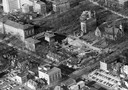
| Description: | Aerial view of Chadbourne Hall under construction on the University of Wisconsin-Madison campus. The new building is at the corner of Park Street and Unive... |
| Date: | 1958 |
|---|---|
| Description: | Aerial view of Chadbourne Hall under construction on the University of Wisconsin-Madison campus at the corner of Park Street and University Avenue. Music H... |
| Date: | 1958 |
|---|---|
| Description: | Aerial View of Eagle Heights Apartments, built especially for married students' housing, under construction on the University of Wisconsin-Madison campus. ... |

| Date: | 1956 |
|---|---|
| Description: | Aerial view of Schenk's Corners where Atwood Avenue and Winnebago Street cross, looking north east. |

| Date: | 1956 |
|---|---|
| Description: | Aerial view of residential homes, farmland and streets. |
If you didn't find the material you searched for, our Library Reference Staff can help.
Call our reference desk at 608-264-6535 or email us at: