Filter: Categories of Wisconsin Historical Images
Filter: Creator Name of Newhouse, John
Filter: County of Dane
Filter: Subject of water
Filter: Categories of Wisconsin Historical Images
Filter: Creator Name of Newhouse, John
Filter: County of Dane
Filter: Subject of water

| Date: | 1950 |
|---|---|
| Description: | Woman with children grilling hot dogs and wieners at the beach. |

| Date: | 1956 |
|---|---|
| Description: | Aerial view looking east along Madison's Lake Mendota shoreline. The large building under construction at center is Carroll Hall, a University of Wisconsin... |

| Date: | 1956 |
|---|---|
| Description: | Aerial view over the eastern end of Lake Mendota, looking northeast. Maple Bluff is in the foreground and Truax Field is in the background. |

| Date: | 1956 |
|---|---|
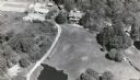
| Description: | Aerial view looking south from a point over the Maple Bluff country club golf course (foreground). A new housing development in the mid-ground and Maple Bl... |

| Date: | 1958 |
|---|---|
| Description: | An aerial view of the construction of a new wing on a state office building. Automobiles are parked in a log along Lake Monona. |

| Date: | 1954 |
|---|---|
| Description: | Looking northwest down Wisconsin Avenue from the Wisconsin State Capitol dome. Mifflin Street is visible in the foreground, while in the center of the phot... |

| Date: | 1960 |
|---|---|
| Description: | Air view of the Lake Mendota Shore looking east. The Edgewater Hotel and Kennedy Manor are at bottom center with Lake Mendota at left. James Madison Park i... |

| Date: | 06 1960 |
|---|---|
| Description: | Aerial view looking northwest showing an area to be redeveloped into high-rise dormitories. Lake Mendota and Bascom Woods can be seen at the top. Universit... |

| Date: | 1962 |
|---|---|
| Description: | Aerial view of the Hilldale Shopping Center and environs. Anchor store is Gimbels. N. Midvale Boulevard runs left to right. The State Department of Transpo... |

| Date: | |
|---|---|
| Description: | Aerial view of the Greenbush neighborhood in winter partially demolished for the Triangle Redevelopment Project. Monona Bay and Brittingham park are at rig... |

| Date: | 1964 |
|---|---|
| Description: | Aerial view of the Sampson Plaza apartment complex on West Washington Avenue, with Proudfit Street running along the bottom. Neighborhood House can be seen... |
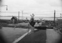
| Date: | |
|---|---|
| Description: | View of a railroad crossing near Lake Monona. Men are on the standing on the road in the background, and other men are working along the railroad tracks. C... |
If you didn't find the material you searched for, our Library Reference Staff can help.
Call our reference desk at 608-264-6535 or email us at: