 Filter: Categories of Wisconsin Historical Images
Filter: Creator Name of Newhouse, John
Filter: Community of Madison
Filter: Categories of Wisconsin Historical Images
Filter: Creator Name of Newhouse, John
Filter: Community of Madison
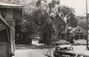
| Date: | 1954 |
|---|---|
| Description: | A view of Fairchild Street from Mifflin Street. There is a sign on the side of the building on the right that reads: "Casey O'Brien." |

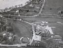
| Date: | |
|---|---|
| Description: | Aerial view of the southeast, with West Broadway and the South Beltline running through the image. Also shows Nob Hill restaurant, the Toki family farm and... |
| Date: | 1955 |
|---|---|
| Description: | The intersection of Johnson and Broom Streets. |

| Date: | 1955 |
|---|---|
| Description: | Doctors Lindley and John T. Sprague house, 109 East Johnson Street. |

| Date: | |
|---|---|
| Description: | Aerial view of the Crestwood neighborhood. |

| Date: | 1955 |
|---|---|
| Description: | A public bus crosses the bridge over a ravine on Lake Mendota Drive in Shorewood, looking east. |

| Date: | 1955 |
|---|---|
| Description: | Bridge over a ravine on Lake Mendota Drive in Shorewood Hills, looking west. |

| Date: | |
|---|---|
| Description: | Aerial view of a full Camp Randall Stadium during half-time of a football game. The band is on the field in formation to spell "UW." |
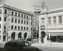
| Date: | 1954 |
|---|---|
| Description: | F.W. Woolworth store on East Main Street at Monona Avenue (now Martin Luther King, Jr., Boulevard), showing the old Vilas block (aka Pioneer Building). |

| Date: | 1955 |
|---|---|
| Description: | View down Monona Avenue, which is now Martin Luther King, Jr. Boulevard, toward Lake Monona. |
| Date: | 1957 |
|---|---|
| Description: | Law Park along Lake Monona, after filling in the shoreline to construct a road and parking lot. This is the current site of the Monona Terrace. |

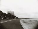
| Date: | 1957 |
|---|---|
| Description: | Law Park along Lake Monona, before filling in the shoreline to construct a road and parking lot. |

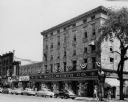
| Date: | 1955 |
|---|---|
| Description: | A view looking northeast along Main Street from near its intersection with Monona Avenue on Capitol Square. |
| Date: | 1957 |
|---|---|
| Description: | An air view of the Maple Bluff Country Club. In the upper lefthand corner is the Rennebohm residence. |
| Date: | 1955 |
|---|---|
| Description: | View of two houses (108 N. Blount and 102 N. Blount) on North Blount Street taken from Market Place showing a corner of the City Market on the left. |
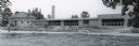
| Date: | 1954 |
|---|---|
| Description: | Panoramic view of the Mendota grade school during construction. |
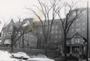
| Date: | 1954 |
|---|---|
| Description: | Methodist Hospital, from West Washington Avenue. |

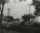
| Date: | 1955 |
|---|---|
| Description: | Midvale Avenue and Odana Boulevard. |
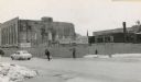
| Date: | 1954 |
|---|---|
| Description: | The intersection of Mifflin Street and Wisconsin Avenue after the old City Hall (1858-1954) and Fuller Opera House had been torn down. |
If you didn't find the material you searched for, our Library Reference Staff can help.
Call our reference desk at 608-264-6535 or email us at:
