Filter: Categories of Wisconsin Historical Images
Filter: Creator Name of Gillett, Sherwin
Filter: Subject of agriculture
Filter: Subject of rural areas
Filter: Categories of Wisconsin Historical Images
Filter: Creator Name of Gillett, Sherwin
Filter: Subject of agriculture
Filter: Subject of rural areas
| Date: | |
|---|---|
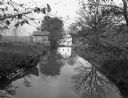
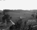
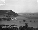
| Description: | Rich Valley looking down at Mill Creek Valley. There are several farmhouses among the fields. |
| Date: | |
|---|---|
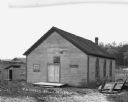
| Description: | Exterior of the one-room United Brethren [?] Church. There is an outhouse to the left of the church. On the right is a hill with trees. Farm building and a... |
| Date: | 1922 |
|---|---|
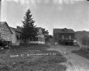
| Description: | View from yard of blacksmith shop, a home, and a two-story building with a "Gold Medal Flour" sign. |
| Date: | |
|---|---|
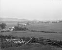
| Description: | View down hill of town in a valley. There is open land, homes, barns and a bee farm. |
| Date: | |
|---|---|
| Description: | Elevated view of farmland. In the bottom-left center, there is a structure with a bell tower near a dirt road. In the center there is a similar building. T... |
| Date: | 1921 |
|---|---|
| Description: | View from hill of a church [?], shed, and cemetery in a valley. A dirt road is on the left. |
| Date: | 1913 |
|---|---|
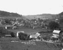
| Description: | Bird's-eye view of the village. Cropland and barns cover much of the landscape. |
| Date: | |
|---|---|
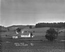
| Description: | A bird's-eye view of a farmland property with barns and farmhouse. |

| Date: | |
|---|---|
| Description: | A group of men and boys pose by a pond. A boy holds a long, probably bamboo, fishing rod. Two men jokingly pose as if they are dancing the tango. |
| Date: | |
|---|---|
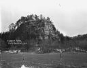
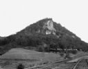
| Description: | View of a large rock formation. There is a fence in the foreground. |

| Date: | 1925 |
|---|---|
| Description: | View of a church, field, and cemetery from a hilltop. A car drives down the road in the lower-right corner. |

| Date: | |
|---|---|
| Description: | View from hill over church and cemetery towards fields and town in a valley. |
| Date: | |
|---|---|
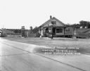
| Description: | Exterior of a gas station/restaurant and the entrance to the Triangle Tourist Park. |
| Date: | 1929 |
|---|---|
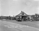
| Description: | Exterior view from road of gas station and "dine and dance" restaurant on Highway US-18/US-12, outside the Triangle Tourist Park. The establishment offers ... |
| Date: | |
|---|---|
| Description: | View across double set of railroad tracks and field towards steep bluff with exposed rock. |
| Date: | 1920 |
|---|---|
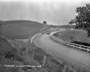
| Description: | View from hillside of car driving down a winding road. Their are cornfields on both sides of the road. |
| Date: | 1910 |
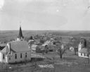
|---|---|
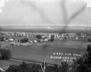
| Description: | Elevated view from hill of Mount Sterlings's churches, homes, and businesses. |
If you didn't find the material you searched for, our Library Reference Staff can help.
Call our reference desk at 608-264-6535 or email us at: