 Filter: Categories of Wisconsin Historical Images
Filter: Creator Name of Draper, Lyman Copeland
Filter: Subject of water
Filter: Categories of Wisconsin Historical Images
Filter: Creator Name of Draper, Lyman Copeland
Filter: Subject of water

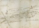
| Date: | 1744 |
|---|---|
| Description: | A map of a plan of 16,500 acres of land. |
| Date: | |
|---|---|
| Description: | Hand-drawn map including the Clinch River and Clinch mountain range. The Clinch River rises in Southwest Virginia near Tazewell, VA and flows southwest thr... |
If you didn't find the material you searched for, our Library Reference Staff can help.
Call our reference desk at 608-264-6535 or email us at:
