 Filter: Categories of Wisconsin Historical Images
Filter: Creator Name of Brown, Charles E.
Filter: Year of 1900-1999
Filter: Categories of Wisconsin Historical Images
Filter: Creator Name of Brown, Charles E.
Filter: Year of 1900-1999
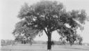
| Date: | 1939 |
|---|---|
| Description: | A man is posing with his left hand resting on the trunk of the General Grant Giant Elm, S.E. of intersection of Green Bay and Good Hope Roads. At site of P... |
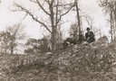
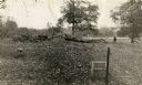
| Date: | 08 1905 |
|---|---|
| Description: | A visitor takes in the sight of three linear burial mounds at the Sure-Johnson mound group south of McFarland, Wisconsin. |
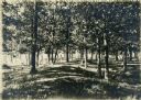
| Date: | 1908 |
|---|---|
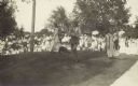
| Description: | Elevated view of Vilas Park, filled with groups of people on the lawn, and horse-drawn carriages on the drive. |
| Date: | 1908 |
|---|---|
| Description: | View looking up towards Reverend F.M. Gilmore, Professor W.E. Leonard, and Charles Brown relaxing on a burial mound on Fox Bluff near Lake Mendota. |
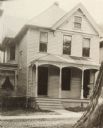
| Date: | 1926 |
|---|---|
| Description: | Exterior view of the Merrick residence, with a woman sitting on a swing on the front porch. |
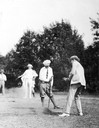
| Date: | 06 23 1923 |
|---|---|
| Description: | Madison Mayor Milo Kittleson hitting the first tee shot on the temporary nine-hole golf course of the Nakoma Country Club at the formal opening on June 23,... |

| Date: | 1910 |
|---|---|
| Description: | Sawmill on a Menominee Indian reservation, with logs floating in the water in the foreground. Caption reads: "Menominee Indian Mills." |
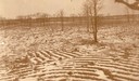
| Date: | 1912 |
|---|---|
| Description: | Indian cultivated garden beds, partially covered with snow, "South of West over the big area." Now known as the Eulrich Site, a mile from the shore of Lake... |
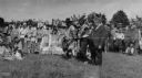
| Date: | 07 09 1919 |
|---|---|
| Description: | Governor Phillip outdoors at a victory celebration. |

| Date: | 03 24 1913 |
|---|---|
| Description: | Picnic Point from the University Farm fields, now known as Observatory Hill. |
| Date: | 1914 |
|---|---|
| Description: | Ceremony for erecting tablets on the Observatory Hill Mounds performed by University of Wisconsin summer session students. |
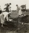
| Date: | 05 30 1931 |
|---|---|
| Description: | W.P. and Vivian Morgan, Grace Rollins and ? Mills excavate a burial mound in the Outlet group at the foot of Lake Monona. |
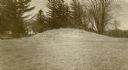
| Date: | 1913 |
|---|---|
| Description: | One of the large burial mounds of the Outlet mound group on the former Hoyt property at the foot of Lake Monona. |
| Date: | 1930 |
|---|---|
| Description: | A linear burial mound and historic marker at the University Ridge mound group on the University of Wisconsin-Madison campus. The mound group was eventually... |

| Date: | 1915 |
|---|---|
| Description: | A row of conical burial mounds adjoins the Park and Pleasure Drive on the north shore of Lake Wingra (now Edgewood Drive, at the south edge of Edgewood Col... |

| Date: | 1910 |
|---|---|
| Description: | Exterior view of St. Andrews Episcopal Church. |
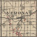
| Date: | 1924 |
|---|---|
| Description: | Map of Verona in Dane County from the Charles Brown Atlas. |

| Date: | 04 12 1912 |
|---|---|
| Description: | Diagram of a bird effigy mound found in Frost's Woods, Blooming Grove Township. |

| Date: | 1930 |
|---|---|
| Description: | This map shows Indian trails through Wisconsin counties. The trail are in red ink. Lake Michigan, Green Bay, Lake Superior, and the Wisconsin River are lab... |

| Date: | 1916 |
|---|---|
| Description: | In 1916, it was estimated that 15,000 Indian mounds had formerly existed in Wisconsin. In the early 20th century, the Wisconsin Archaeological Society surv... |
If you didn't find the material you searched for, our Library Reference Staff can help.
Call our reference desk at 608-264-6535 or email us at: