 Filter: Categories of Wisconsin Historical Images
Filter: Creator Name of Brown, Charles E.
Filter: Subject of land use
Filter: Year of 1900-1999
Filter: Categories of Wisconsin Historical Images
Filter: Creator Name of Brown, Charles E.
Filter: Subject of land use
Filter: Year of 1900-1999
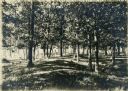
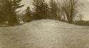
| Date: | 08 1905 |
|---|---|
| Description: | A visitor takes in the sight of three linear burial mounds at the Sure-Johnson mound group south of McFarland, Wisconsin. |
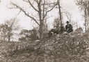
| Date: | 1908 |
|---|---|
| Description: | View looking up towards Reverend F.M. Gilmore, Professor W.E. Leonard, and Charles Brown relaxing on a burial mound on Fox Bluff near Lake Mendota. |

| Date: | 03 24 1913 |
|---|---|
| Description: | Picnic Point from the University Farm fields, now known as Observatory Hill. |
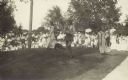
| Date: | 1914 |
|---|---|
| Description: | Ceremony for erecting tablets on the Observatory Hill Mounds performed by University of Wisconsin summer session students. |
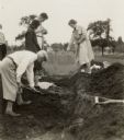
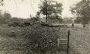
| Date: | 05 30 1931 |
|---|---|
| Description: | W.P. and Vivian Morgan, Grace Rollins and ? Mills excavate a burial mound in the Outlet group at the foot of Lake Monona. |
| Date: | 1913 |
|---|---|
| Description: | One of the large burial mounds of the Outlet mound group on the former Hoyt property at the foot of Lake Monona. |
| Date: | 1930 |
|---|---|
| Description: | A linear burial mound and historic marker at the University Ridge mound group on the University of Wisconsin-Madison campus. The mound group was eventually... |

| Date: | 1915 |
|---|---|
| Description: | A row of conical burial mounds adjoins the Park and Pleasure Drive on the north shore of Lake Wingra (now Edgewood Drive, at the south edge of Edgewood Col... |

| Date: | 04 12 1912 |
|---|---|
| Description: | Diagram of a bird effigy mound found in Frost's Woods, Blooming Grove Township. |

| Date: | 1916 |
|---|---|
| Description: | In 1916, it was estimated that 15,000 Indian mounds had formerly existed in Wisconsin. In the early 20th century, the Wisconsin Archaeological Society surv... |

| Date: | 1913 |
|---|---|
| Description: | Ink and watercolor on tracing cloth. Shows parts of Green Lake, Princeton, and Brooklyn townships, Indian mound groups, Green Lake, and other significant b... |

| Date: | 1944 |
|---|---|
| Description: | Portage County Map. Includes the towns of Eau Plaine, Dewey, Sharon, Alban, Carson, Hull, New Hope, Linwood, Stockton, Amherst, Plover, Grant, Buena Vista,... |

| Date: | 11 03 1903 |
|---|---|
| Description: | A drawing of a group of burial mounds in Linden Valley. Text on back reads: "These mounds lie at the narrow mouth of Linden Valley on the east side of the ... |

| Date: | 1924 |
|---|---|
| Description: | A map of the Madison Township, T7N R9E including Lake Mendota showing the location of Ho Chunk encampments and effigy mounds. |
If you didn't find the material you searched for, our Library Reference Staff can help.
Call our reference desk at 608-264-6535 or email us at: