 Filter: Categories of Wisconsin Historical Images
Filter: Creator Name of Brown, Charles E.
Filter: County of Dane
Filter: Subject of cities and towns
Filter: Year of 1900-1999
Filter: Categories of Wisconsin Historical Images
Filter: Creator Name of Brown, Charles E.
Filter: County of Dane
Filter: Subject of cities and towns
Filter: Year of 1900-1999

| Date: | 1915 |
|---|---|
| Description: | A row of conical burial mounds adjoins the Park and Pleasure Drive on the north shore of Lake Wingra (now Edgewood Drive, at the south edge of Edgewood Col... |

| Date: | 1910 |
|---|---|
| Description: | Exterior view of St. Andrews Episcopal Church. |
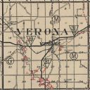
| Date: | 1924 |
|---|---|
| Description: | Map of Verona in Dane County from the Charles Brown Atlas. |

| Date: | 04 12 1912 |
|---|---|
| Description: | Diagram of a bird effigy mound found in Frost's Woods, Blooming Grove Township. |

| Date: | 1924 |
|---|---|
| Description: | This map of the Four Lakes region shows points of interest around the lakes, state trunk highways and other roads, railroads, and lakes and streams. Manusc... |

| Date: | 1924 |
|---|---|
| Description: | A map of the Madison Township, T7N R9E including Lake Mendota showing the location of Ho Chunk encampments and effigy mounds. |
If you didn't find the material you searched for, our Library Reference Staff can help.
Call our reference desk at 608-264-6535 or email us at: