 Filter: Categories of Wisconsin Historical Images
Filter: Creator Name of Born, Allan
Filter: Subject of roads
Filter: County of Ashland
Filter: Categories of Wisconsin Historical Images
Filter: Creator Name of Born, Allan
Filter: Subject of roads
Filter: County of Ashland
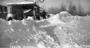
| Date: | 1937 |
|---|---|
| Description: | Winter scene with snow piled high in front of Red Crown gasoline station. A man is standing next to the Red Crown gas pump. |
| Date: | 1937 |
|---|---|
| Description: | Winter scene with snow plowed high on County Road M, Clam Lake (Ashland Co.), Wisconsin. The Chippewa Tavern is visible in the background, and the building... |

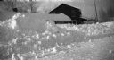
| Date: | 1937 |
|---|---|
| Description: | View from across road of a one-story building with stairs leading from the dirt road to the porch; an outhouse is behind the inn. Numerous beer signs are o... |
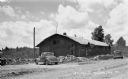
| Date: | 1937 |
|---|---|
| Description: | Gas pump and automobile next to a tavern on county Road D near Clam Lake. |
| Date: | 1938 |
|---|---|
| Description: | A man is exiting a wooden building with a Blatz beer sign hanging on the front and two automobiles parked nearby. Near Clam Lake. |
| Date: | 1938 |
|---|---|
| Description: | Elevated view of Melody Haven Tavern near Clam Lake. A man is standing next to a stone wall surrounding a parking lot. |
| Date: | 1938 |
|---|---|
| Description: | Automobile ruts leading through trees past dwellings on a hill. |
| Date: | 1938 |
|---|---|
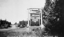
| Description: | A car can be seen in the distance driving down the highway towards an entrance sign for "McCorison's Clam Lake Lodge-Cabins Boats Musky Pike Bass." |
| Date: | 1935 |
|---|---|
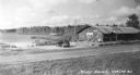
| Description: | Elevated view across road of people and automobiles in front of homes and businesses along a dirt road. In the background is a local grocery store, tavern ... |

| Date: | 1938 |
|---|---|
| Description: | A coupe rag top automobile that has been modified with tracks, sitting atop a trailer in front of the County Courthouse. |
| Date: | 1935 |
|---|---|
| Description: | Aerial view of Madeline Island including the tennis courts, houses, and the Old Mission Inn. |

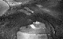
| Date: | 1934 |
|---|---|
| Description: | Tree-lined dirt road curving along Madeline Island. |
| Date: | 1934 |
|---|---|
| Description: | Aerial view of Big Bay on Madeline Island. This area later became Big Bay State Park. |
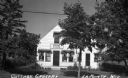
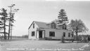
| Date: | 1935 |
|---|---|
| Description: | View from road of Cottage Grocery store on Main Street on Madeline Island. |
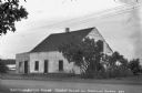
| Date: | 1935 |
|---|---|
| Description: | White stucco house with wooden addition next to Lake Superior on Madeline Island. At the time of the photograph this was the oldest house on Madeline Islan... |
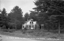
| Date: | 1938 |
|---|---|
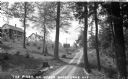
| Description: | View from road of two-story white hotel with a screen porch; a sign advertising "The Pines" is attached onto two pine trees in front of the hotel. |
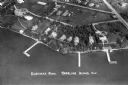
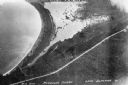
| Date: | 1937 |
|---|---|
| Description: | Aerial view of Nebraska Row on the lakeshore of the west side of La Pointe, showing houses, roads and piers. Nebraska Row was started in 1899 when summer r... |

| Date: | 1931 |
|---|---|
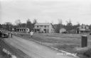
| Description: | View looking east on Grant Street in Glidden Wisconsin. |
If you didn't find the material you searched for, our Library Reference Staff can help.
Call our reference desk at 608-264-6535 or email us at:

