 Filter: Categories of Wisconsin Historical Images
Filter: Type of Map or Atlas
Filter: Year of 1900-1999
Filter: Categories of Wisconsin Historical Images
Filter: Type of Map or Atlas
Filter: Year of 1900-1999

| Date: | 1922 |
|---|---|
| Description: | A plat map of the township of Delton near the Wisconsin River. |
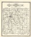
| Date: | 1922 |
|---|---|
| Description: | A plat map by Westfield created by George A. Ogle & Co. |

| Date: | 1912 |
|---|---|
| Description: | A plat map of the township of Casco. Created by Geo. A. Ogle. |

| Date: | 1914 |
|---|---|
| Description: | Pg. 44 West Half of Marion Township. Pg. 45 East Half of Marion Township. |

| Date: | 1914 |
|---|---|
| Description: | A farmer's directory of Marion Township listing farmers and locations of their farms. |

| Date: | 1910 |
|---|---|
| Description: | A land ownership map of the township of Leroy. |

| Date: | 1900 |
|---|---|
| Description: | A Sanborn fire insurance map of Sauk City created in 1900. |

| Date: | 1915 |
|---|---|
| Description: | A Sanborn fire insurance map of Sauk City created in 1915. |

| Date: | 1915 |
|---|---|
| Description: | A Sanborn fire insurance map of Sauk City created in 1915. |

| Date: | 1900 |
|---|---|
| Description: | A Sanborn fire insurance map of Sauk City created in 1900. |

| Date: | 09 1918 |
|---|---|
| Description: | An insurance map of Washburn, with an index and a key. Includes a small inset map of the State of Wisconsin that shows "Location of this town as above unde... |

| Date: | 1969 |
|---|---|
| Description: | A map of Wisconsin from The Atlas of the Eight Counties of Forest, Florence, Iron, Langlade, Lincoln, Oneida, Price, Vilas. The map shows rivers and a vari... |
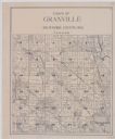
| Date: | 1920 |
|---|---|
| Description: | A plat map of the town of Granville in Milwaukee County, Wisconsin. |
| Date: | 1978 |
|---|---|
| Description: | A map showing allotments of American Indian tribes in Ottawa County, Oklahoma. On the left side is a listing of Lead & Zinc Mines. |

| Date: | 1997 |
|---|---|
| Description: | System map including Wisconsin Central LTD., Fox Valley and Western LTD., Algoma Central Railway, Inc., and Sault Ste. Marie Bridge Co. Detail maps at top ... |

| Date: | 1915 |
|---|---|
| Description: | A composite plat map of the towns of Mequon, Saukville, Belgium, Fort Washington, and Fredonia. |

| Date: | 1921 |
|---|---|
| Description: | A plat map of Mequon, Wisconsin. Text at top reads: "T. 9N. R.21 E MEQUON T. 9N. R.22 E." |

| Date: | 1923 |
|---|---|
| Description: | Color map of the "Interborough Rapid Transit System of Greater New York". |

| Date: | 1923 |
|---|---|
| Description: | The back side of the map of the "Interborough Rapid Transit System of Greater New York". |
If you didn't find the material you searched for, our Library Reference Staff can help.
Call our reference desk at 608-264-6535 or email us at:
