Filter: Categories of Wisconsin Historical Images
Filter: Type of Map or Atlas
Filter: Categories of Wisconsin Historical Images
Filter: Type of Map or Atlas

| Date: | 1854 |
|---|---|
| Description: | A sketch of the public surveys of Wisconsin and territory of Minnesota. |

| Date: | 1899 |
|---|---|
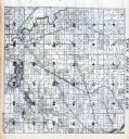
| Description: | A plat map of Burke, Cottage Grove, McFarland, Waunakee, Quarry Town, Klevenville, and Vilas. |

| Date: | 1908 |
|---|---|
| Description: | A Sanborn map including a portion of the East Johnson Street and East Gorham Street neighborhood. |

| Date: | 1908 |
|---|---|
| Description: | A Sanborn map of the isthmus, which includes the map key. |

| Date: | 1912 |
|---|---|
| Description: | A plat map of the township of West Kewaunee. |

| Date: | 1980 |
|---|---|
| Description: | The general theme of this black and white map is "Discover and Enjoy Wisconsin." The front of the map depicts driving tours numbered 1 through 12; each to... |

| Date: | 1977 |
|---|---|
| Description: | This colored map displays Wisconsin and portions of bordering states, including a detailed map of the Wisconsin Dells area. Surrounding the map are multipl... |

| Date: | 1976 |
|---|---|
| Description: | This colored map displays Wisconsin and portions of bordering states, including a detailed map of the Wisconsin Dells area. Surrounding the map are multipl... |

| Date: | 1975 |
|---|---|
| Description: | This colored road map of Wisconsin displays "Featured Points of Interest" and "Historical Points of Interest" in the state, including three color photograp... |

| Date: | 1973 |
|---|---|
| Description: | This colored map displays Wisconsin and bordering areas of Iowa, Minnesota, and Michigan. There is color-coding on the map to indicate National Forests, a... |

| Date: | 1971 |
|---|---|
| Description: | This colored map displays Wisconsin and bordering areas of Iowa, Minnesota, and Michigan. There is color-coding on the map to indicate National Forests, an... |

| Date: | 1970 |
|---|---|
| Description: | This colored map displays detailed maps of Green Bay, Appleton, Racine, Milwaukee, Kenosha, and Duluth-Superior. At the top right is a map location list of... |

| Date: | 1972 |
|---|---|
| Description: | This colored map displays Wisconsin and bordering areas of Iowa, Minnesota, and Michigan. There is color-coding on the map to indicate National Forests, an... |

| Date: | 1966 |
|---|---|
| Description: | This colored road map shows automobile roads in Wisconsin as well as portions of nearby states. Information on the quality and type of any road shown (inte... |
If you didn't find the material you searched for, our Library Reference Staff can help.
Call our reference desk at 608-264-6535 or email us at: