Filter: Categories of Wisconsin Historical Images
Filter: Type of Map or Atlas
Filter: Subject of rivers
Filter: Categories of Wisconsin Historical Images
Filter: Type of Map or Atlas
Filter: Subject of rivers

| Date: | 1757 |
|---|---|
| Description: | The Canadian Lakes. Scale [ca. 1:6,500,000]. Paris: 1757. |

| Date: | 1857 |
|---|---|
| Description: | Green Lake County plat map, T. 17 N, R. 13 E. |

| Date: | 1857 |
|---|---|
| Description: | Green Lake County plat map, T. 14 N, R. 13 E. |

| Date: | 1857 |
|---|---|
| Description: | Green Lake County plat map, T. 16 N, R. 12 E. |

| Date: | 1857 |
|---|---|
| Description: | Green Lake County plat map, T. 17 N, R. 12 E. |

| Date: | 1857 |
|---|---|
| Description: | Green Lake County plat map, T. 14 N, R. 12 E. |
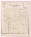
| Date: | 1873 |
|---|---|
| Description: | A plat map of the town of Pleasant Springs. |

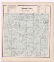
| Date: | 1899 |
|---|---|
| Description: | A plat map of the township of Christiana. |

| Date: | 1914 |
|---|---|
| Description: | Pg. 44 West Half of Marion Township. Pg. 45 East Half of Marion Township. |

| Date: | 1857 |
|---|---|
| Description: | Green Lake County Abstract plat map, T. 14 N, R. 11 E. |

| Date: | 1857 |
|---|---|
| Description: | Green Lake County abstract plat map, T. 16 N, R. 11 E. |

| Date: | 1857 |
|---|---|
| Description: | Green Lake County plat map, T. 15 N., R. 12 E. |
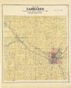
| Date: | 1889 |
|---|---|
| Description: | A plat map of Larrabee, township 25 north, range 14 east. |
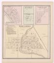
| Date: | 1873 |
|---|---|
| Description: | A page showing four plat maps: Stoughton, Clifton, Deanville, and Cross Plains. |
If you didn't find the material you searched for, our Library Reference Staff can help.
Call our reference desk at 608-264-6535 or email us at: