 Filter: Categories of Wisconsin Historical Images
Filter: Type of Map or Atlas
Filter: Community of Oshkosh
Filter: Categories of Wisconsin Historical Images
Filter: Type of Map or Atlas
Filter: Community of Oshkosh

| Date: | 1850 |
|---|---|
| Description: | Bird's-eye view of business district of Oshkosh, "drawn after nature" by the artist. |

| Date: | 1867 |
|---|---|
| Description: | Bird's-eye view of Oshkosh, "drawn from nature." |
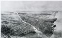
| Date: | 1911 |
|---|---|
| Description: | Black and white image, looking west from Lake Winnebago with Fox River flowing from top left corner to bottom right corner. Streets laid out with indicatio... |

| Date: | 1875 |
|---|---|
| Description: | Bird's-eye map after a fire destroyed a large area of the town. In memory of the Great Conflagration on April 28th, 1875. Taken from the North-Side. |

| Date: | 1950 |
|---|---|
| Description: | This map of the business section of Oshkosh shows businesses and lot owners. The map is oriented with north to the left and includes 2 "continued inset" ma... |

| Date: | 09 1950 |
|---|---|
| Description: | This map show streets, points of interest, Lake Winnebago and bays, Lake Butte Des Morts, and the Fox River. The back of the map includes a directory of t... |

| Date: | 1962 |
|---|---|
| Description: | This map shows streets, points of interest, Lake Winnebago, Millers Bay, South Asylum Bay, Lake Butte des Morts, and the Fox River. The map also includes a... |

| Date: | 1962 |
|---|---|
| Description: | This map shows streets, points of interest, Lake Winnebago, Millers Bay, South Asylum Bay, Lake Butte des Morts, and the Fox River. The map also includes a... |

| Date: | 06 1890 |
|---|---|
| Description: | This map shows building use, railroads, tramways, lumber yards, roads, watchman’s stations, and steam pipes. Also included is text about buildings, Clapp a... |

| Date: | 1930 |
|---|---|
| Description: | This map shows city wards, streets, railroads, parks, Lake Butte Des Morts, Lake Winnebago, advertisements for Dixie Oils Gasoline, a list of Cook & Brown ... |

| Date: | 1858 |
|---|---|
| Description: | This map shows city wards, streets, block and lot numbers, cemeteries, buildings, landownership, forests, railroads, a race course, quarries, and orchards.... |

| Date: | 1877 |
|---|---|
| Description: | This map shows the Fox River, Lake Winnebago, city wards, lot and block numbers, landownership, selected buildings, railroads, and roads. There are three i... |

| Date: | 1908 |
|---|---|
| Description: | This blueprint map is showing subdivisions and additions. Streets, rivers, and land plots are labeled. |

| Date: | 1855 |
|---|---|
| Description: | This map shows the Fox River, Lake Winnebago, streets, and plats. Below the title reads: "N. F.&Co. will make surveys of lands and plat the same in the bes... |

| Date: | 1900 |
|---|---|
| Description: | Map showing a paper city located on the shore of Green Bay and south shore of the Fox River. The site is now part of Oshkosh. |

| Date: | 1900 |
|---|---|
| Description: | Map showing city wards, streets, block and lot numbers, additions, selected buildings, Lake Winnebago, the Fox River, and railroads as of 1895. The lower m... |

| Date: | 1926 |
|---|---|
| Description: | This blueprint map is oriented with north to the upper left. The map shows buildings with note of those "to be torn down," sidewalks, proposed power plant,... |
If you didn't find the material you searched for, our Library Reference Staff can help.
Call our reference desk at 608-264-6535 or email us at: