 Filter: Categories of Wisconsin Historical Images
Filter: Type of Map or Atlas
Filter: Community of Menasha
Filter: Categories of Wisconsin Historical Images
Filter: Type of Map or Atlas
Filter: Community of Menasha

| Date: | 08 24 1899 |
|---|---|
| Description: | Pen-and-ink and color on paper. Also shows probable routes of the French explorers Constant le Marchand de Lignery in 1728 and Louis de la Porte de Louvign... |

| Date: | 1920 |
|---|---|
| Description: | Shows lot and block numbers. Includes manuscript annotations showing original Wisconsin Central Railway line in red which reads: "Original W.C. Line in Men... |
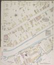
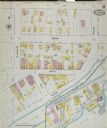
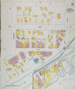
| Date: | 1884 |
|---|---|
| Description: | Sanborn-Perris fire insurance map for city of Menasha. |
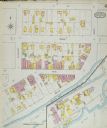
| Date: | 1884 |
|---|---|
| Description: | Sanborn-Perris fire insurance map for city of Menasha. |
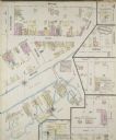
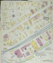
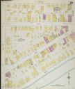
| Date: | 1887 |
|---|---|
| Description: | Sanborn-Perris fire insurance maps for city of Menasha. |
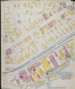
| Date: | 1887 |
|---|---|
| Description: | Sanborn-Perris fire insurance maps for city of Menasha. |
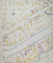
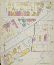
| Date: | 1891 |
|---|---|
| Description: | Sanborn-Perris fire insurance maps for city of Menasha. |
| Date: | 1891 |
|---|---|
| Description: | Sanborn-Perris fire insurance maps for city of Menasha. |
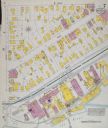
| Date: | 1895 |
|---|---|
| Description: | Sanborn-Perris fire insurance maps for city of Menasha. |
| Date: | 1895 |
|---|---|
| Description: | Sanborn-Perris fire insurance maps for city of Menasha. |
| Date: | |
|---|---|
| Description: | Sanborn-Perris fire insurance maps for city of Menasha. |
| Date: | 1900 |
|---|---|
| Description: | Sanborn-Perris fire insurance maps for city of Menasha. |
| Date: | 1900 |
|---|---|
| Description: | Sanborn-Perris fire insurance maps for city of Menasha. |
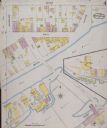
| Date: | |
|---|---|
| Description: | Sanborn-Perris Map of Menasha from 1900 page 7. |

| Date: | 1872 |
|---|---|
| Description: | Shows landowners, buildings, lot numbers, roads and railroads. Includes Menasha business directory. |

| Date: | 1881 |
|---|---|
| Description: | Ink, watercolor, and pencil on paper. Top of the map reads: "NORTHERN OUTLET MENASHA MEANDER LINES Scale 132ft 1 INCH Var S.E. Survey Completed Spet. 23 18... |

| Date: | 1712 |
|---|---|
| Description: | This drawing, based on an 1897 survey, appeared in the 1899 Proceedings of the State Historical Society of Wisconsin, accompanying Publius V. Lawson's arti... |

| Date: | 1945 |
|---|---|
| Description: | This map shows block and lot numbers, subdivisions, streets, railroads, and abandoned right of ways. Some areas are shown in yellow and pink. The city seal... |

| Date: | 1931 |
|---|---|
| Description: | This map shows heavy industrial districts (yellow), commercial and light manufacturing districts (red), and residential districts (white) as well as a plat... |
If you didn't find the material you searched for, our Library Reference Staff can help.
Call our reference desk at 608-264-6535 or email us at:
