 Filter: Categories of Wisconsin Historical Images
Filter: COLLECTION_NAME of Rare Books
Filter: Subject of rivers
Filter: Categories of Wisconsin Historical Images
Filter: COLLECTION_NAME of Rare Books
Filter: Subject of rivers

| Date: | 1821 |
|---|---|
| Description: | Engraving depicting the Schoolcraft expedition crossing the Ontonagon River to investigate a copper boulder. |
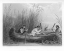
| Date: | 1884 |
|---|---|
| Description: | Three women in a canoe harvest wild rice. |
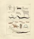
| Date: | 1851 |
|---|---|
| Description: | Pictographs on Lake Superior and Carp River, Mich. Six rows of animals, canoes, birds, human figures, and other symbols. |
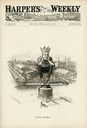
| Date: | 07 14 1894 |
|---|---|
| Description: | Cartoon depicting "King Debs" a man wearing a crown representing Debs American Railway Union, sitting atop the highway of trade. |
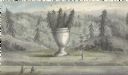
| Date: | |
|---|---|
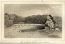
| Description: | Artists depiction of a natural rock formation called "The Urn," which is 17 feet tall with another 10 feet of trees growing on top of the formation. |
| Date: | |
|---|---|
| Description: | Illustration of an area with water and trees showing men hiding in the brush. |

| Date: | 1857 |
|---|---|
| Description: | An etching showing the landscape and vegetation around the Rio Grande. |
| Date: | |
|---|---|
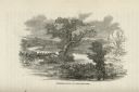
| Description: | Depiction of the fall of Kettle River including a rock formation in the river and surrounding landscape filled with trees. |

| Date: | 05 05 1970 |
|---|---|
| Description: | Steve Landaal and two friends sit on a log over a creek at the Sound Storm rock festival. They are enjoying nude sunbathing. |

| Date: | 05 05 1970 |
|---|---|
| Description: | Steve Landall embraces his girlfirend while standing in a creek at the Sound Storm rock festival. |

| Date: | 02 1823 |
|---|---|
| Description: | A map featuring the North American expedition from Pittsburgh to the Rocky Mountains led by Edwin James. |

| Date: | 1698 |
|---|---|
| Description: | An illustration of two men looking out at Niagara Falls. The Niagara Falls in Jean Louis Hennepin’s A new discovery of a vast country in America (London: M... |

| Date: | 02 01 1793 |
|---|---|
| Description: | Text in the upper right corner reads, "A Map of The Western Part of the Territories belonging to the United States of America. Drawn from the best authorit... |
| Date: | 1856 |
|---|---|
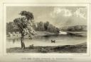
| Description: | Lithographic view of Four Legs Village at the outlet of Lake Winnebago. There are is a person in a canoe on the river and a large tree in the foreground. S... |
| Date: | 1856 |
|---|---|
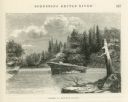
| Description: | Lithographic view of the Grande Chute Falls on the Fox River. There is a tent on the shore on the right. |
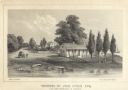
| Date: | 1856 |
|---|---|
| Description: | Lithograhic view of the residence of John Kinzie on the bank of the Chicago River at the mouth of Lake Michigan. The residence consists of a house with a f... |

| Date: | |
|---|---|
| Description: | A map captioned: "Diagram of the Region Destitute of Drift and Boulders in Wisconsin, Iowa and Minnesota." |

| Date: | 1867 |
|---|---|
| Description: | A map and profile map of the railroad line from Omaha to San Francisco. |
If you didn't find the material you searched for, our Library Reference Staff can help.
Call our reference desk at 608-264-6535 or email us at: