Filter: Categories of Wisconsin Historical Images
Filter: COLLECTION_NAME of Rare Books
Filter: Subject of human settlements
Filter: Categories of Wisconsin Historical Images
Filter: COLLECTION_NAME of Rare Books
Filter: Subject of human settlements
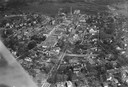
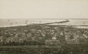
| Date: | 1925 |
|---|---|
| Description: | Aerial photograph taken as part of a survey by the Wisconsin Power and Light Company to promote economic development by emphasizing available buildings and... |
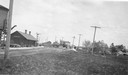
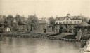
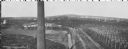
| Date: | 1925 |
|---|---|
| Description: | Railroad depot taken as part of a survey by the Wisconsin Power and Light Company to promote economic development by emphasizing available buildings and bu... |

| Date: | 1655 |
|---|---|
| Description: | Map of Virginia Coast based on observations by Captain John Smith. |
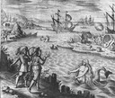
| Date: | 1655 |
|---|---|
| Description: | Scene of the Jamestown Settlement in Virginia, ca. 1614 showing men at the water's edge being beckoned by mermaids. |

| Date: | 1655 |
|---|---|
| Description: | Map from Drake Expedition, ca. 1585. |

| Date: | 1655 |
|---|---|
| Description: | Map from Drake Expedition in Florida, ca. 1585. |
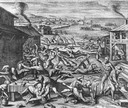
| Date: | 1655 |
|---|---|
| Description: | Scene from Jamestown Settlement, 1622, purporting to show the massacre of 347 settlers by Openchancanough and his alliance of tribes in the Jamestown area. |
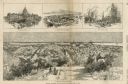
| Date: | 03 30 1889 |
|---|---|
| Description: | Bird's-eye view from Bascom Hill of Madison, with vignettes of the Wisconsin State Capitol, Lake Monona, and the Capitol Park. |
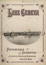
| Date: | 1904 |
|---|---|
| Description: | Title page of a picturesque and descriptive book about Lake Geneva showing two steamboats "Lady Of The Lake" and "Lucius Newberry." |
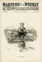
| Date: | 07 14 1894 |
|---|---|
| Description: | Cartoon depicting "King Debs" a man wearing a crown representing Debs American Railway Union, sitting atop the highway of trade. |

| Date: | 1848 |
|---|---|
| Description: | Foldout map of a sketch of the town grid of Calumet. |
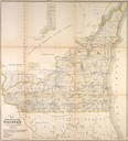
| Date: | 1849 |
|---|---|
| Description: | Foldout map of southern Wisconsin. |

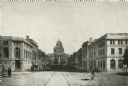
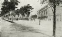
| Date: | 1906 |
|---|---|
| Description: | View of Lake Mendota Drive at the foot of Stevens Hill. |
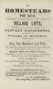
| Date: | 1855 |
|---|---|
| Description: | Advertisment of Leonard J. Farwell from the 1855 Madison City Directory for the real estate property he had for sale. At the time Farwell was the largest ... |
| Date: | |
|---|---|
| Description: | Drawing of proposed park on State Street at the corner of Broom and Gorham Streets. |
| Date: | |
|---|---|
| Description: | Elevated view of Washburn with a brick tower in the foreground. |
If you didn't find the material you searched for, our Library Reference Staff can help.
Call our reference desk at 608-264-6535 or email us at: