Filter: Categories of Wisconsin Historical Images
Filter: COLLECTION_NAME of Place File*****
Filter: Subject of botany
Filter: County of Crawford
Filter: Categories of Wisconsin Historical Images
Filter: COLLECTION_NAME of Place File*****
Filter: Subject of botany
Filter: County of Crawford

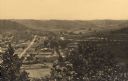
| Date: | 1905 |
|---|---|
| Description: | Elevated view of Soldiers' Grove with a bridge in the foreground. |
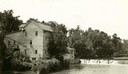
| Date: | 1920 |
|---|---|
| Description: | A large building, possibly a mill, next to a river. |
| Date: | 1880 |
|---|---|
| Description: | Elevated view of Artesian Well, located near the intersection of Wisconsin Street and South Minnesota Street (since renamed Wacouta). It was dubbed by some... |
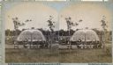
| Date: | 1880 |
|---|---|
| Description: | Stereograph of the Artesian Well near the intersection of Wisconsin and Minnesota (later renamed Wacouta) Streets. The following is printed on the backside... |
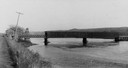
| Date: | 1900 |
|---|---|
| Description: | View from road of a partially covered bridge. Industrial buildings are near the entrance to the bridge on the left. |

| Date: | 1895 |
|---|---|
| Description: | View down road with the Bay State House on the left. Three houses and a barbershop also line the street. A lamppost is in the left foreground. The Mississ... |

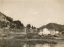
| Date: | 1902 |
|---|---|
| Description: | River with distant hills behind a town. An island is in the foreground. |
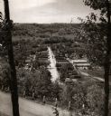
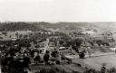
| Date: | 1950 |
|---|---|
| Description: | View from hill through two trees over a road with a guard fence, overlooking the town laid out along a main thoroughfare. The area is heavily forested, and... |
| Date: | |
|---|---|
| Description: | Elevated view of Gays Mills, with tree-covered hills in the background. |
| Date: | 1946 |
|---|---|
| Description: | Elevated view from hill of Gays Mills. Tree-covered hills are in the distance. |
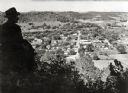
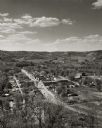
| Date: | 1940 |
|---|---|
| Description: | View of Gays Mills from a bluff overlooking the town. A man is sitting on a fence in the left foreground. |

| Date: | 1908 |
|---|---|
| Description: | Elevated view of Wauzeka. A bridge over a river is in the background. |

| Date: | 09 1962 |
|---|---|
| Description: | The Mississippi River along Highway 35. |

| Date: | 1898 |
|---|---|
| Description: | View from water tower, showing the grove where Black Hawk's pursuers were supposed to have camped in 1832. The group of men in the foreground are digging f... |
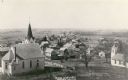
| Date: | 1915 |
|---|---|
| Description: | Elevated view of the town with a church building in the left foreground. Caption reads: "Birds Eye View Mt Sterling, Wis." |
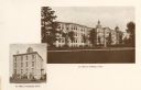
| Date: | 1922 |
|---|---|
| Description: | View of St. Mary's Institute in 1872, and a view of St. Mary's College in 1922. |
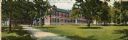
| Date: | 1905 |
|---|---|
| Description: | Exterior view of the Prairie du Chien Sanitarium. Established in 1903, it became a general hospital in the 1930s. A group of people are posing on the lawn ... |
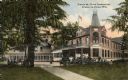
| Date: | 1907 |
|---|---|
| Description: | View of Prairie du Chien Sanitarium. "The grounds where this sanitarium stands was the site of Gen. Taylor's headquarters at Fort Crawford in 1832. It was ... |
If you didn't find the material you searched for, our Library Reference Staff can help.
Call our reference desk at 608-264-6535 or email us at: