Filter: Categories of Wisconsin Historical Images
Filter: COLLECTION_NAME of Place File****
Filter: Subject of real estate development
Filter: Categories of Wisconsin Historical Images
Filter: COLLECTION_NAME of Place File****
Filter: Subject of real estate development

| Date: | 1898 |
|---|---|
| Description: | University Heights from the Chemistry Building on University Avenue. View includes the University of Wisconsin-Madison football field, on the former site o... |
| Date: | 1909 |
|---|---|
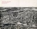
| Description: | Illustration of town. Caption reads: "Bird's-eye View, Lyons, Wisconsin. A Village of natural environments, choice residence locations, desirable factory s... |
| Date: | 1901 |
|---|---|
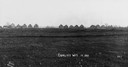
| Description: | Thirteen unfinished houses in a row, on the horizon of a field. Captin reads: "Corliss Wis In 1901". |

| Date: | 1867 |
|---|---|
| Description: | Drawn map showing planned development of Cornell, including a couple of schools, Oakwood cemetery, the public square, and several bridges and dams. |

| Date: | 1956 |
|---|---|
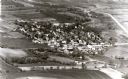
| Description: | Aerial view looking south from a point over the Maple Bluff country club golf course (foreground). A new housing development in the mid-ground and Maple Bl... |
| Date: | 1927 |
|---|---|
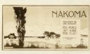
| Description: | Postcard for Nakoma Realty Company. Caption reads: "Nakoma, You'll Enjoy The Wide Outdoors! 150 Acres Set Aside For Play! A Madison Realty Co. Property." |
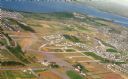
| Date: | 09 1958 |
|---|---|
| Description: | An aerial view of University Hill Farms on Madison's west side, a complete 604 acre community developed by the Regents of the University of Wisconsin. Real... |
If you didn't find the material you searched for, our Library Reference Staff can help.
Call our reference desk at 608-264-6535 or email us at: