Filter: Categories of Wisconsin Historical Images
Filter: COLLECTION_NAME of Place File****
Filter: Subject of outdoor photography
Filter: Creator Name of Unknown
Filter: Categories of Wisconsin Historical Images
Filter: COLLECTION_NAME of Place File****
Filter: Subject of outdoor photography
Filter: Creator Name of Unknown
| Date: | 1935 |
|---|---|
| Description: | Close-up of the Radisson and Groseilliers house historic site marker, commemorating the first house built in Wisconsin by white men. The house was believed... |
| Date: | 1944 |
|---|---|
| Description: | View of the Radisson and Groseilliers marker at the site of the first house built by white men in Wisconsin. The marker is located in the vicinity of Ashla... |
| Date: | 1900 |
|---|---|
| Description: | Railway passenger depot in Ashland (?), Wisconsin. |
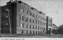
| Date: | 1905 |
|---|---|
| Description: | Caption reads: "St. Joseph's Hospital, Ashland, Wis." Front facade and grounds of the four-story, red brick hospital built in 1905. The basement level is b... |
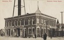
| Date: | |
|---|---|
| Description: | View from street of the Augusta State Bank on a corner. There are pedestrians walking on the street and along the sidewalk. There is a support structure fo... |
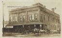
| Date: | |
|---|---|
| Description: | View from street of a group of people, including a number of horse-drawn vehicles, standing outside of the main entrance to the Cox Brothers company on Cox... |
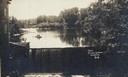
| Date: | |
|---|---|
| Description: | Front view of dam and waterfall at Dells Pond. There is a building on the left of the dam. People are fishing from a boat on the pond. |
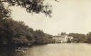
| Date: | |
|---|---|
| Description: | Caption reads: "Mill Pond, Augusta, Wis." View across water towards a large building on the far shoreline. Tree-lined shore on the left. |

| Date: | |
|---|---|
| Description: | Photographic postcard of Stone Street. A car is parked in front of an auto repair store. Electric power lines run down the street, and a water tower is in ... |
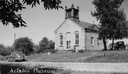
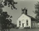
| Date: | 1950 |
|---|---|
| Description: | Exterior view of the Aztalan Museum after restoration. The building, originally a church with a steeple, was built in 1852. |
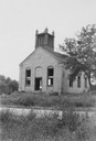
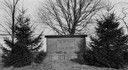
| Date: | 1941 |
|---|---|
| Description: | View of the Aztalan Baptist Church prior to restoration by the Lake Mills-Aztalan Historical Society. |
| Date: | 1910 |
|---|---|
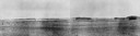
| Description: | View of the Crawfish River in the vicinity of Aztalan. |
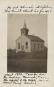
| Date: | 1920 |
|---|---|
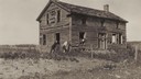
| Description: | View of an old home or inn. Two people are looking out of an open window, and two men are standing outside leaning against the building. |

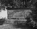
| Date: | 08 14 1932 |
|---|---|
| Description: | The watershed sign unveiled. The marker is 39 miles south of Ashland adjacent to Highway 13, 2 miles north of Gordon Lake. |

| Date: | 08 14 1932 |
|---|---|
| Description: | Watershed sign unveiled with ceremony participants. The marker is 39 miles south of Ashland adjacent to Highway 13, 2 miles north of Gordon Lake. |
If you didn't find the material you searched for, our Library Reference Staff can help.
Call our reference desk at 608-264-6535 or email us at: