Filter: Categories of Wisconsin Historical Images
Filter: COLLECTION_NAME of Place File****
Filter: Subject of land use, urban
Filter: Categories of Wisconsin Historical Images
Filter: COLLECTION_NAME of Place File****
Filter: Subject of land use, urban

| Date: | 1960 |
|---|---|
| Description: | Elevated view looking east from Lincoln Terrace on Bascom Hill on the University of Wisconsin-Madison campus. The Lincoln Monument is in the foreground and... |

| Date: | 1955 |
|---|---|
| Description: | A nighttime view of the Wisconsin State Capitol as seen from Monona Avenue (South Wisconsin Avenue until December 1, 1877; Martin Luther King Jr. Boulevard... |

| Date: | 02 1964 |
|---|---|
| Description: | Nighttime winter scene on University of Wisconsin-Madison campus of the Carillon Tower with the Social Sciences building in the background. |

| Date: | 1945 |
|---|---|
| Description: | View of the lower campus of the University of Wisconsin-Madison includes Bascom Hill, Wisconsin Historical Society, Memorial Union and the Armory (Red Gym ... |

| Date: | 1926 |
|---|---|
| Description: | Originally titled 'Recent Aeroplane View of University Campus', the view of the Wisconsin Historical Society, the Red Gym, Science Hall and Bascom Hall wit... |

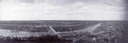
| Date: | 1930 |
|---|---|
| Description: | Aerial view of the city and the river. |

| Date: | 1955 |
|---|---|
| Description: | Aerial view of town, with the Baraboo River. |
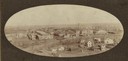
| Date: | 1900 |
|---|---|
| Description: | Elevated view of the company buildings and residential area, with view of skyline. |
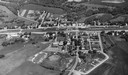
| Date: | 1923 |
|---|---|
| Description: | Aerial view of town with river. The clipping from a newspaper has a description titled: "Seeing Wisconsin From an Airplane". |

| Date: | 1965 |
|---|---|
| Description: | Aerial view of downtown Big Falls and the Little Wolf River. The Little Wolf River is at lower right. |
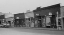
| Date: | 1956 |
|---|---|
| Description: | View across Canal Street with the businesses that were built after the fire. Ford stepside truck is parked along the curb on the left. Businesses with thre... |
| Date: | 1910 |
|---|---|
| Description: | Aerial view of town, with a river and the horizon in the distance. |

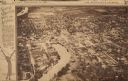
| Date: | 1867 |
|---|---|
| Description: | Drawn map showing planned development of Cornell, including a couple of schools, Oakwood cemetery, the public square, and several bridges and dams. |

| Date: | 1955 |
|---|---|
| Description: | Aerial view of Cross Plains, with countryside surrounding and hills on the horizon. |
If you didn't find the material you searched for, our Library Reference Staff can help.
Call our reference desk at 608-264-6535 or email us at: