Filter: Categories of Wisconsin Historical Images
Filter: COLLECTION_NAME of Place File****
Filter: Subject of intellectual life
Filter: Categories of Wisconsin Historical Images
Filter: COLLECTION_NAME of Place File****
Filter: Subject of intellectual life

| Date: | 1952 |
|---|---|
| Description: | Aerial view of a North Central Airlines DC-3 airplane flying over the Madison isthmus. Clearly visible are the Wisconsin State Capitol, the 1 West Wilson S... |
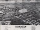
| Date: | 1882 |
|---|---|
| Description: | Bird's-eye map of Poynette, with one vignette. |

| Date: | 1940 |
|---|---|
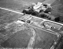
| Description: | Aerial view looking east over the center of the city and the University of Wisconsin-Madison campus. |

| Date: | 1908 |
|---|---|
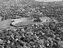
| Description: | Aerial view of Camp Randall Field on the University of Wisconsin-Madison campus. University Heights is in the background. |

| Date: | 1928 |
|---|---|
| Description: | Aerial view of the Wisconsin State Capitol, looking northeast. The Park Hotel on the corner of W. Main Street and S. Carroll Street, is in the foreground. |
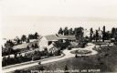
| Date: | 1925 |
|---|---|
| Description: | Aerial view of Woods' Manor on shores of Madeline Island. The manor was built in 1900 for summer resident Colonel Frederick Woods from Nebraska. |
| Date: | 1952 |
|---|---|
| Description: | Aerial view of City Stadium, former home of the Green Bay Packers from 1925 to 1956. Currently it is the home of the Green Bay East High School football te... |
| Date: | 1908 |
|---|---|
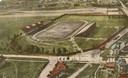
| Description: | Colorized aerial view of Camp Randall Stadium at the University of Wisconsin-Madison. |

| Date: | 07 10 1949 |
|---|---|
| Description: | Aerial view of Minocqua showing the surrounding lakes. |
| Date: | 1948 |
|---|---|
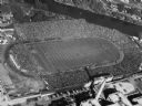
| Description: | Aerial view of Camp Randall Stadium and Field House. |

| Date: | 1879 |
|---|---|
| Description: | Bird's-eye view of Wisconsin State University, now the University of Wisconsin-Madison. Vignettes include Ladies Hall, South Dormitory, University Hall, As... |

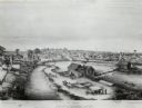
| Date: | 1861 |
|---|---|
| Description: | Bird's-eye map of Fond du Lac, "drawn after nature," with a parade of soldiers marching down the street. |

| Date: | 1875 |
|---|---|
| Description: | Bird's-eye map after a fire destroyed a large area of the town. In memory of the Great Conflagration on April 28th, 1875. Taken from the North-Side. |

| Date: | 1893 |
|---|---|
| Description: | Bird's-eye map of Sturgeon Bay, looking Northeast. Area bordered by Church Street in top left corner, leather & Smith Bridge in bottom left corner, Lawrenc... |

| Date: | 1880 |
|---|---|
| Description: | Bird's-eye map of Sturgeon Bay. County Seat of Door County. |

| Date: | 02 26 1887 |
|---|---|
| Description: | Bird's-eye map of Ashland, and the Apostle Islands in Lake Superior. Caption reads: "Ashland and the Apostle Islands." |
If you didn't find the material you searched for, our Library Reference Staff can help.
Call our reference desk at 608-264-6535 or email us at: