Filter: Categories of Wisconsin Historical Images
Filter: COLLECTION_NAME of Place File**
Filter: Year of 1800-1899
Filter: Year of 1860-1869
Filter: Categories of Wisconsin Historical Images
Filter: COLLECTION_NAME of Place File**
Filter: Year of 1800-1899
Filter: Year of 1860-1869
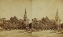
| Date: | 1860 |
|---|---|
| Description: | College Avenue looking west from the corner of Morrison Street. The building on the left is the Adkins Building, at the right is the Johnston House. This w... |

| Date: | 1862 |
|---|---|
| Description: | Camp Randall looking southwest. In April 1861, Governor Alexander Randall asked that the State Agricultural Society fairgrounds be converted into a militar... |
| Date: | 1860 |
|---|---|
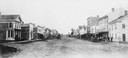
| Description: | Elevated view of Barstow Street looking north. View from the corner of Main Street, where the Eau Claire Book and Stationary Company later stood, looking n... |

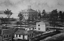
| Date: | 1868 |
|---|---|
| Description: | Illustration of the exterior of the Second Ward School House, copied from the 1868 Madison City Directory. |

| Date: | 1861 |
|---|---|
| Description: | Bird's-eye map of Fond du Lac, "drawn after nature," with a parade of soldiers marching down the street. |
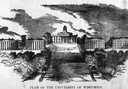
| Date: | 1860 |
|---|---|
| Description: | Illustrated view of the plan for University of Wisconsin of University Hill, Bascom Hill, area. |
| Date: | 1860 |
|---|---|
| Description: | Elevated illustration of the Lawrence College Campus with snow on the ground. |
| Date: | 1860 |
|---|---|
| Description: | Stereograph of a Methodist Church with a lawn, trees and a fence. |
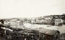
| Date: | 1868 |
|---|---|
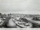
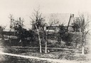
| Description: | View of the Baraboo River and surrounding structures. |
| Date: | 1869 |
|---|---|
| Description: | View of the Berlin High School, with children playing and people walking in the foreground. |
| Date: | 1864 |
|---|---|
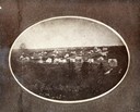
| Description: | Oval-framed view of the village, founded by Delos W. Taft, had its name changed to Bloomington in 1867. It had been named Tafton. |

| Date: | 1865 |
|---|---|
| Description: | Elevated view of the Congregational church and surrounding buildings. |

| Date: | 1865 |
|---|---|
| Description: | Family portrait of the Porters, standing in front of their log cabin with a horse. |

| Date: | 1867 |
|---|---|
| Description: | Drawn map showing planned development of Cornell, including a couple of schools, Oakwood cemetery, the public square, and several bridges and dams. |
| Date: | 1863 |
|---|---|
| Description: | Exterior of St. John Chrysostom Episcopal Church, with trees and a fence in the foreground. |
| Date: | 1860 |
|---|---|
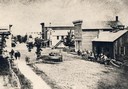
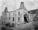
| Description: | Exterior view of the Garden City Brewery, built in 1854. A person is on horseback in the yard below on the left, and a man is standing above them in an ope... |
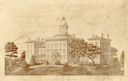
| Date: | 1860 |
|---|---|
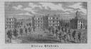
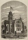
| Description: | Engraved print of the institute. The building has dome, and at the top is a wind vane. Caption reads: "Wisconsin Institute for the Deaf & Dumb." |
If you didn't find the material you searched for, our Library Reference Staff can help.
Call our reference desk at 608-264-6535 or email us at: