 Filter: Categories of Wisconsin Historical Images
Filter: COLLECTION_NAME of Place File**
Filter: Year of 1800-1899
Filter: Subject of water
Filter: Categories of Wisconsin Historical Images
Filter: COLLECTION_NAME of Place File**
Filter: Year of 1800-1899
Filter: Subject of water

| Date: | 1851 |
|---|---|
| Description: | A rare photograph of U.S. Army soldiers stationed at Fort Howard rowing a boat on the Fox River. Fort Howard, built in 1816, was the first in the chain of ... |
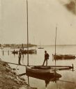
| Date: | 1890 |
|---|---|
| Description: | Two men pose on a boat docked at the Askew Steamboat Landing on Lake Monona off South Carroll Street. The old Governor Harvey residence is in the backgroun... |
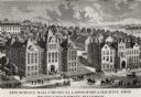
| Date: | 1887 |
|---|---|
| Description: | Engraving of an elevated view of Science Hall, Chemical Laboratory and Machine Shop on the University of Wisconsin-Madison campus. |

| Date: | 1898 |
|---|---|
| Description: | Old Mission Residence at La Pointe, Madeline Island. |
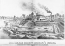
| Date: | 1880 |
|---|---|
| Description: | Lithograph of the Milwaukee Cement Company's Works at 154 West Water Street in Milwaukee. |

| Date: | 1850 |
|---|---|
| Description: | Painting depicting Chippewa Falls and the first sawmill on the Chippewa River, built by Jean Brunet. The residence of H.S. Allen, one of the owners of the... |
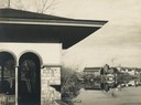
| Date: | 04 24 1899 |
|---|---|
| Description: | Partial view of a boathouse at the foot of North Carroll Street, designed by Frank Lloyd Wright and built for the city of Madison. The University of Wiscon... |

| Date: | 1873 |
|---|---|
| Description: | Newspaper reproduction of an etching of the Milwaukee River. |
| Date: | 1877 |
|---|---|
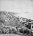
| Description: | View of bluffs and buildings on the shore of Lake Michigan. |
| Date: | 1880 |
|---|---|
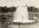
| Description: | Elevated view of Artesian Well, located near the intersection of Wisconsin Street and South Minnesota Street (since renamed Wacouta). It was dubbed by some... |
| Date: | 1880 |
|---|---|
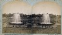
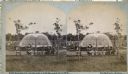
| Description: | Stereograph of the Artesian Well near the intersection of Wisconsin and Minnesota (later renamed Wacouta) Streets. The following is printed on the back of ... |

| Date: | 1879 |
|---|---|
| Description: | Bird's-eye view of Wisconsin State University, now the University of Wisconsin-Madison. Vignettes include Ladies Hall, South Dormitory, University Hall, As... |

| Date: | 1893 |
|---|---|
| Description: | Bird's-eye map of Sturgeon Bay, looking Northeast. Area bordered by Church Street in top left corner, leather & Smith Bridge in bottom left corner, Lawrenc... |

| Date: | 1880 |
|---|---|
| Description: | Bird's-eye map of Sturgeon Bay. County Seat of Door County. |

| Date: | 02 26 1887 |
|---|---|
| Description: | Bird's-eye map of Ashland, and the Apostle Islands in Lake Superior. Caption reads: "Ashland and the Apostle Islands." |

| Date: | 1885 |
|---|---|
| Description: | Ore dock of the Milwaukee, Lake Shore, and Western Railroad, with a pile of logs in the foreground and docked ships in the background. |
| Date: | 1898 |
|---|---|
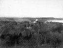
| Description: | Elevated view of Observatory Hill, Observatory Hall, the Agriculture Campus and Lake Mendota on the University of Wisconsin-Madison Campus. |
| Date: | 1897 |
|---|---|
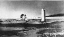
| Description: | Long view of the Minnesota Point lighthouse, built at the entrance to Superior Harbor. It is allegedly the first lighthouse at the head of Lake Superior. |
| Date: | 1880 |
|---|---|
| Description: | Stereograph of the Artesian Well near the intersection of Wisconsin and Minnesota (later renamed Wacouta) Streets. The following is printed on the backside... |
If you didn't find the material you searched for, our Library Reference Staff can help.
Call our reference desk at 608-264-6535 or email us at:
