Filter: Categories of Wisconsin Historical Images
Filter: COLLECTION_NAME of Place File**
Filter: Subject of persons
Filter: Subject of trees
Filter: Categories of Wisconsin Historical Images
Filter: COLLECTION_NAME of Place File**
Filter: Subject of persons
Filter: Subject of trees
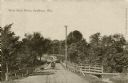
| Date: | 1911 |
|---|---|
| Description: | View down center of West Park Drive. There is a man driving an automobile on the bridge. Caption reads: "West Park Drive, Wis." |
| Date: | |
|---|---|
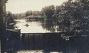
| Description: | Front view of dam and waterfall at Dells Pond. There is a building on the left of the dam. People are fishing from a boat on the pond. |
| Date: | |
|---|---|
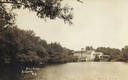
| Description: | Caption reads: "Mill Pond, Augusta, Wis." View across water towards a large building on the far shoreline. Tree-lined shore on the left. |

| Date: | |
|---|---|
| Description: | Photographic postcard of Stone Street. A car is parked in front of an auto repair store. Electric power lines run down the street, and a water tower is in ... |
| Date: | |
|---|---|
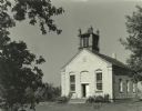
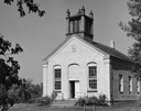
| Description: | Aztalan Museum, exterior of building. The original building was used as a church and construction was concluded in 1852. |
| Date: | 1941 |
|---|---|
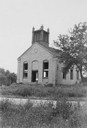
| Description: | View of the Aztalan Baptist Church prior to restoration by the Lake Mills-Aztalan Historical Society. |
| Date: | 1910 |
|---|---|
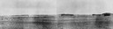
| Description: | View of the Crawfish River in the vicinity of Aztalan. |
| Date: | |
|---|---|
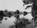
| Description: | View from shoreline across Crawfish River, with foliage and a barbed wire fence in the foreground. |
| Date: | 1945 |
|---|---|
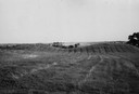
| Description: | Field with contours, and two mounds. |

| Date: | 08 14 1932 |
|---|---|
| Description: | The watershed sign unveiled. The marker is 39 miles south of Ashland adjacent to Highway 13, 2 miles north of Gordon Lake. |

| Date: | 08 14 1932 |
|---|---|
| Description: | Watershed sign unveiled with ceremony participants. The marker is 39 miles south of Ashland adjacent to Highway 13, 2 miles north of Gordon Lake. |
| Date: | |
|---|---|
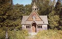
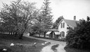
| Description: | Privately built chapel, decorated in Norwegian style by Mr. and Mrs. Boynton. |
| Date: | 1905 |
|---|---|
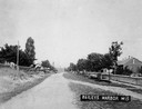
| Description: | View down road. There is a long fence and a sidewalk on the right side. Houses and trees are on both sides of the road. Caption reads: "Baileys Harbor Wis"... |
| Date: | 1898 |
|---|---|
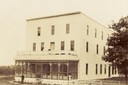
| Description: | Balsam Lake Hotel. A person is standing just outside of the hotel. A fence and tree are on the right. |
| Date: | 1905 |
|---|---|
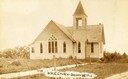
| Description: | The Methodist Episcopal Church in Balsam Lake. Caption reads: 1ST M. E. Church — Balsam Lake WIS". |
| Date: | 1905 |
|---|---|
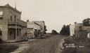
| Description: | View down unpaved street with commercial buildings. Caption reads: "St. Scene, Bancroft, Wis." |
| Date: | 1925 |
|---|---|
| Description: | Exterior view down road towards Helen Baldwin's restaurant. |
If you didn't find the material you searched for, our Library Reference Staff can help.
Call our reference desk at 608-264-6535 or email us at: