Filter: Categories of Wisconsin Historical Images
Filter: COLLECTION_NAME of Place File**
Filter: Subject of persons
Filter: County of Iowa
Filter: Subject of dwellings
Filter: Categories of Wisconsin Historical Images
Filter: COLLECTION_NAME of Place File**
Filter: Subject of persons
Filter: County of Iowa
Filter: Subject of dwellings
| Date: | 1953 |
|---|---|
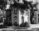
| Description: | Dr. William H. Brisbane house, also known as the Thudium house. It was built between 1868 and 1869 from locally quarried stone for Dr. Brisbane, a physicia... |
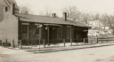
| Date: | 1912 |
|---|---|
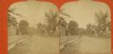
| Description: | View down sidewalk in a residential street, with a house on the right. Caption reads: "A pretty Resident St., Barneveld, Wis." |
| Date: | 11 08 1918 |
|---|---|
| Description: | Governor Henry Dodge's home with trees lining the property line. |
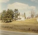
| Date: | 1964 |
|---|---|
| Description: | A brick house with tall windows, and foliage growing on the outer walls. There is a low stone fence in front of it. |
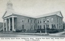
| Date: | 1958 |
|---|---|
| Description: | Elevated view of the gardens and buildings of the Iowa County Court House. |
| Date: | 1900 |
|---|---|
| Description: | View across street towards people standing on the sidewalk in front of the Iowa County Court House. |
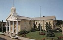
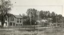
| Date: | 1935 |
|---|---|
| Description: | Iowa County court house with people sitting on the lawn. The wing on the right was added in 1927. Caption reads: "Iowa County Court House, Dodgeville, Wisc... |
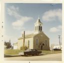
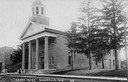
| Date: | 1971 |
|---|---|
| Description: | A stone church built in 1851 located at the junction of Highway 39 and County Trunk X in Linden. |
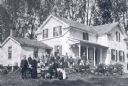
| Date: | 1890 |
|---|---|
| Description: | Exterior view of the home of Samuel Rundell, with a large group of people assembled on the lawn in front of the house. |
| Date: | 1940 |
|---|---|
| Description: | A Cornish home in Mineral Point. In the background is a small hill with trees. |

| Date: | 1930 |
|---|---|
| Description: | The home of a Cornish miner in Mineral Point. Houses are on a hill in the background. |
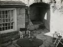
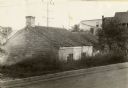
| Date: | 1946 |
|---|---|
| Description: | Slightly elevated view of the patio area of a Cornish house. |
| Date: | 1910 |
|---|---|
| Description: | View across open area and fence towards the Cornish homes on Shakerag Street in Mineral Point. |
| Date: | 1925 |
|---|---|
| Description: | View from road looking down slope toward the house of a Cornish miner. Other buildings are in the background on the right. |
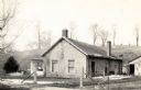
| Date: | 12 1971 |
|---|---|
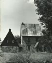
| Description: | An abandoned farm house located on Highway 39 between Linden and Mineral Point. |
| Date: | 1940 |
|---|---|
| Description: | A cottage on the corner of Fountain Street and Chestnut Street. |

| Date: | 1932 |
|---|---|
| Description: | The home of Joseph Gundry, a dry goods merchant. The house was later acquired for use as a museum by the Mineral Point Historical Society. |

| Date: | 1932 |
|---|---|
| Description: | The home of Joseph Gundry, a dry goods merchant. The house was later acquired for use as a museum by the Mineral Point Historical Society. |
If you didn't find the material you searched for, our Library Reference Staff can help.
Call our reference desk at 608-264-6535 or email us at: